File:PIA17930 Curiosity's View Past Dune at 'Dingo Gap'.jpg
Jump to navigation
Jump to search

Size of this preview: 800 × 283 pixels. Other resolutions: 320 × 113 pixels | 640 × 226 pixels | 1,024 × 362 pixels | 1,280 × 452 pixels | 4,075 × 1,439 pixels.
Original file (4,075 × 1,439 pixels, file size: 856 KB, MIME type: image/jpeg)
Captions
Captions
Add a one-line explanation of what this file represents
Summary[edit]
| Description |
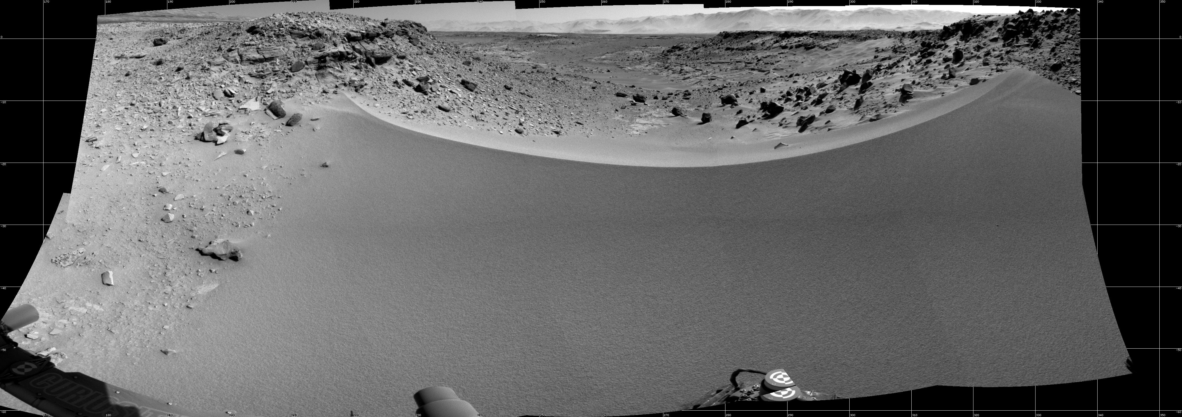
English: This mosaic of images from the Navigation Camera (Navcam) on NASA's Mars rover Curiosity shows the terrain to the west from the rover's position on the 528th Martian day, or sol, of the mission (Jan. 30, 2014). The images were taken right after Curiosity had arrived at the eastern edge of a location called "Dingo Gap." A dune across the gap is about 3 feet (1 meter) high in the middle and tapered at south and north ends onto low scarps on either side of the gap. The rover team is evaluating possible driving routes on the other side before a decision whether the cross the gap.
The view covers a panorama from south, at the left edge, to north-northwest at the right edge. It is presented as a cylindrical projection. NASA's Jet Propulsion Laboratory, a division of the California Institute of Technology, Pasadena, manages the Mars Science Laboratory Project for NASA's Science Mission Directorate, Washington. JPL designed and built the project's Curiosity rover. More information about Curiosity is online at http://www.nasa.gov/msl and http://mars.jpl.nasa.gov/msl/.Polski: Mozaika połączonych zdjęć wykonanych przez kamerę nawigacyjną należącego do NASA łazika Curiosity, pokazuje teren położony na zachód od pozycji łazika aktualnej w 528 marsjańskim dniu, lub Sol, misji łazika na Marsie (30 stycznia 2014). Zdjęcie zostało wykonane po przybyciu Curiosity do wschodniej krawędzi lokalizacji nazwanej "Dingo Gap". Wydma przebiegająca w poprzek luki ma w środku wysokość około 1 metra i jest oparta na południowym i północnym końcu o niewysokie skarpy. Zespół kierujący pracą łazika oceniał inne możliwe trasy, zanim podjął decyzję o przejechaniu poprzez omawianą lukę. Widok obejmuje panoramę od południa, z lewej strony, do północnego zachodu, z prawej strony, co jest przedstawione w formie walcowego odwzorowania terenu. |
| Date | (published 31 January 2014) |
| Source | Catalog page · Full-res (JPEG · TIFF) |
| Author | NASA/JPL-Caltech |
| Location on Mars | View this and other nearby images on: Google Maps |
|---|
This image or video was catalogued by Jet Propulsion Laboratory of the United States National Aeronautics and Space Administration (NASA) under Photo ID: PIA17930. This tag does not indicate the copyright status of the attached work. A normal copyright tag is still required. See Commons:Licensing. Other languages:
|
| This media is a product of the Mars Science Laboratory mission Credit and attribution belongs to the Curiosity rover Navigation Camera (Navcam) team, NASA/JPL-Caltech |
Licensing[edit]
| This file is in the public domain in the United States because it was solely created by NASA. NASA copyright policy states that "NASA material is not protected by copyright unless noted". (See Template:PD-USGov, NASA copyright policy page or JPL Image Use Policy.) | ||
 |
Warnings:
|
File history
Click on a date/time to view the file as it appeared at that time.
| Date/Time | Thumbnail | Dimensions | User | Comment | |
|---|---|---|---|---|---|
| current | 19:08, 4 February 2014 | 4,075 × 1,439 (856 KB) | Spideog (talk | contribs) | User created page with UploadWizard |
You cannot overwrite this file.
File usage on Commons
The following page uses this file:
- File:PIA17930 - Curiosity views dune at Dingo Gap.jpg (file redirect)
File usage on other wikis
The following other wikis use this file:
- Usage on pl.wikipedia.org