File:PIA14455 - Light-Toned Layering in a Labyrinthus Noctis Pit.jpg
Jump to navigation
Jump to search

Size of this preview: 800 × 500 pixels. Other resolutions: 320 × 200 pixels | 640 × 400 pixels | 1,024 × 640 pixels | 1,280 × 800 pixels | 2,880 × 1,800 pixels.
Original file (2,880 × 1,800 pixels, file size: 1,002 KB, MIME type: image/jpeg)
Captions
Captions
Add a one-line explanation of what this file represents
Summary[edit]
| Description |
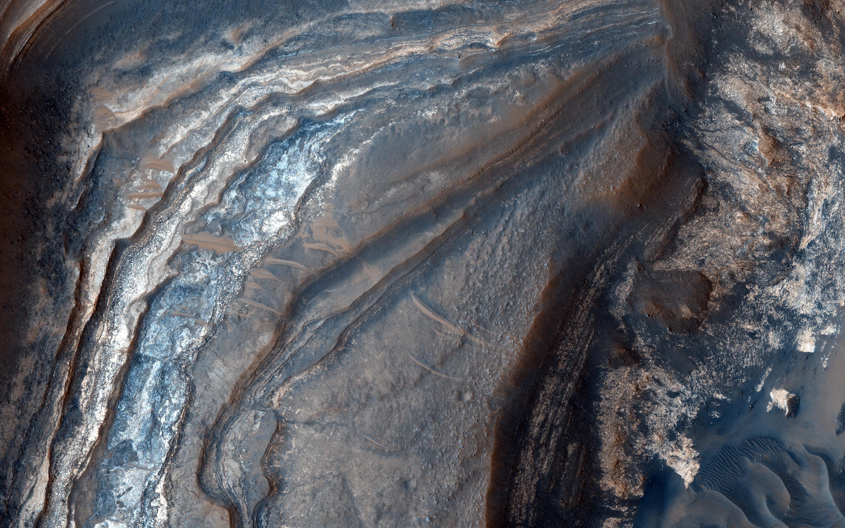
English: Understanding both the spatial and temporal distribution of hydrated (water-bearing) minerals on Mars is essential for deciphering the aqueous history of the planet. Over 300 meters of layered beds are exposed in this trough of Noctis Labyrinthus, at the western edge of Valles Marineris.
The beds are mixtures of light- and dark-toned materials, and include units that contain hydrated minerals, like sulfates and clays. Mapping these minerals and their stratigraphic relationships indicates numerous hydrologic and/or depositional events in localized environments spread over time. The diversity of materials within the trough implies active hydrologic processes and/or changing chemical conditions, perhaps due to influxes of groundwater from nearby Tharsis volcanism. This is a stereo pair with PSP_003910_1685. The University of Arizona, Tucson, operates HiRISE, which was built by Ball Aerospace & Technologies Corp., Boulder, Colo. NASA's Jet Propulsion Laboratory, a division of Caltech in Pasadena, California, manages the Mars Reconnaissance Orbiter Project for NASA's Science Mission Directorate, Washington. |
| Date | 21 September 2007 (published 3 January 2017) |
| Source | Catalog page · Full-res (JPEG · TIFF) |
| Author | NASA/JPL-Caltech/Univ. of Arizona |
| Location on Mars | View this and other nearby images on: Google Maps |
|---|
This image or video was catalogued by Jet Propulsion Laboratory of the United States National Aeronautics and Space Administration (NASA) under Photo ID: PIA14455. This tag does not indicate the copyright status of the attached work. A normal copyright tag is still required. See Commons:Licensing. Other languages:
|
 |
This media is a product of the Mars Reconnaissance Orbiter mission Credit and attribution belongs to the High Resolution Imaging Science Experiment (HiRISE) team, NASA/JPL-Caltech/Univ. of Arizona |
Licensing[edit]
| This file is in the public domain in the United States because it was solely created by NASA. NASA copyright policy states that "NASA material is not protected by copyright unless noted". (See Template:PD-USGov, NASA copyright policy page or JPL Image Use Policy.) | ||
 |
Warnings:
|
File history
Click on a date/time to view the file as it appeared at that time.
| Date/Time | Thumbnail | Dimensions | User | Comment | |
|---|---|---|---|---|---|
| current | 00:08, 7 January 2017 | | 2,880 × 1,800 (1,002 KB) | PhilipTerryGraham (talk | contribs) | User created page with UploadWizard |
You cannot overwrite this file.
File usage on Commons
The following 5 pages use this file: