File:PIA13181 - Muddy Ejecta Flow.jpg

Original file (2,880 × 1,800 pixels, file size: 1.32 MB, MIME type: image/jpeg)
Captions
Captions
Summary[edit]
| Description |
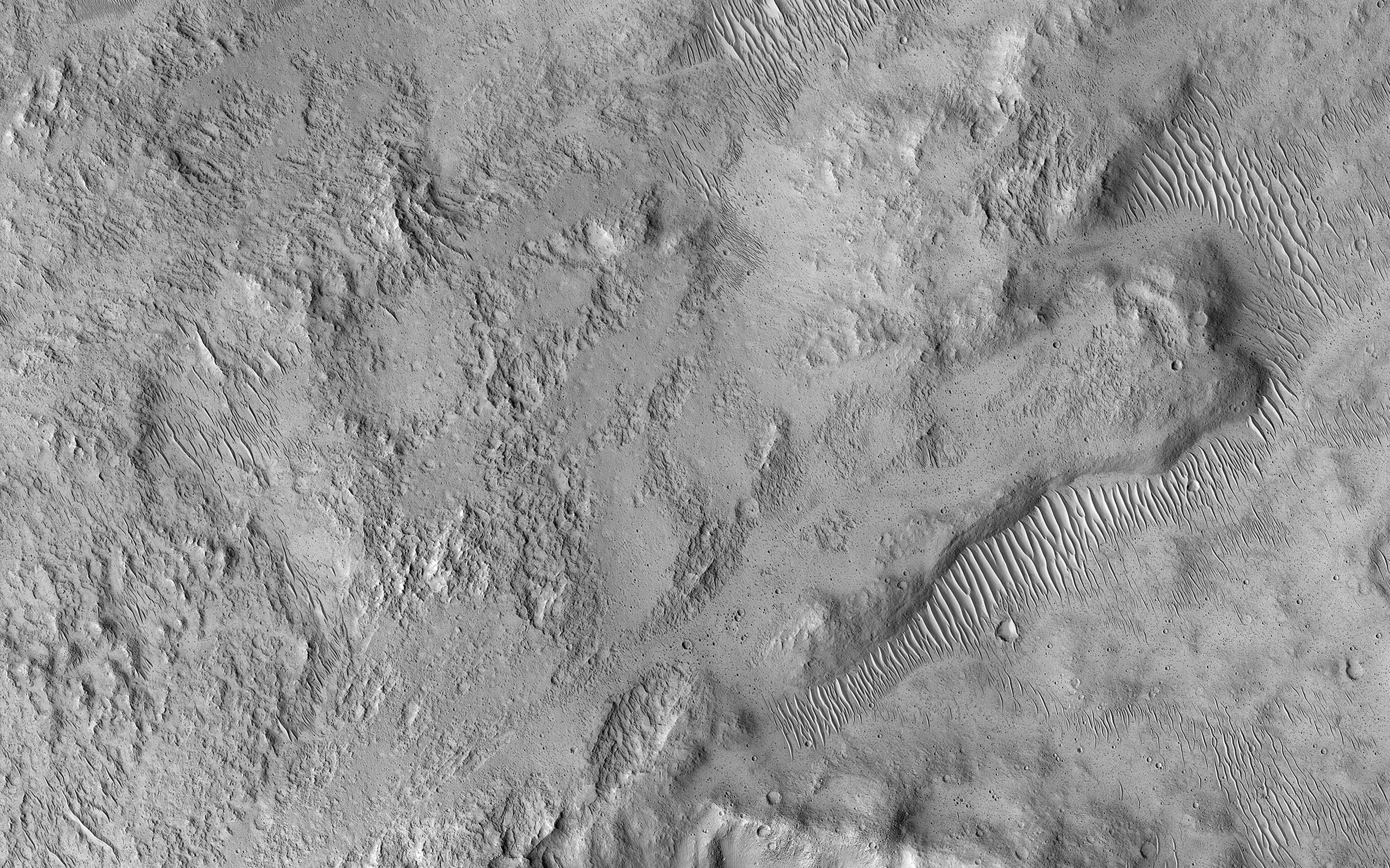
English: This small 2 kilometer-wide crater was sitting around, minding its own business when a meteoroid struck the ground just to the west and created a new, larger crater almost 10 kilometers in diameter (not pictured).
The ejecta spraying out of the new crater landed back on the ground and then continued to flow away from the new crater, and the smaller crater was in the way of that muddy flow. You can see where much of the muddy material flowed around the crater's uplifted rim and forms a squiggly ridge, but you can also see where the mud flow slid over the rim and ponded down in the bottom of the crater. One question we don't know the answer to is: "how wet was the muddy ejecta?" Ongoing observations like this and laboratory-based experiments are trying to find the answer to that question. This image also illustrates a common theme in geology, namely, the law of superposition. Because the crater has been affected by ejecta from the larger crater to the west, the small crater had to be there first and then the second, larger crater and its ejecta had to form. This allows planetary geologists to decipher the relative ages of different landforms. Because a central goal of geology is to understand past events from present-day clues, geology is sometimes compared to forensic science. This is a stereo pair with ESP_037612_1940. The University of Arizona, Tucson, operates HiRISE, which was built by Ball Aerospace & Technologies Corp., Boulder, Colo. NASA's Jet Propulsion Laboratory, a division of Caltech in Pasadena, California, manages the Mars Reconnaissance Orbiter Project for NASA's Science Mission Directorate, Washington. |
| Date | 24 July 2016 (published 10 January 2017) |
| Source | Catalog page · Full-res (JPEG · TIFF) |
| Author | NASA/JPL-Caltech/Univ. of Arizona |
| Location on Mars | View this and other nearby images on: Google Maps |
|---|
This image or video was catalogued by Jet Propulsion Laboratory of the United States National Aeronautics and Space Administration (NASA) under Photo ID: PIA13181. This tag does not indicate the copyright status of the attached work. A normal copyright tag is still required. See Commons:Licensing. Other languages:
|
 |
This media is a product of the Mars Reconnaissance Orbiter mission Credit and attribution belongs to the High Resolution Imaging Science Experiment (HiRISE) team, NASA/JPL-Caltech/Univ. of Arizona |
Licensing[edit]
| This file is in the public domain in the United States because it was solely created by NASA. NASA copyright policy states that "NASA material is not protected by copyright unless noted". (See Template:PD-USGov, NASA copyright policy page or JPL Image Use Policy.) | ||
 |
Warnings:
|
File history
Click on a date/time to view the file as it appeared at that time.
| Date/Time | Thumbnail | Dimensions | User | Comment | |
|---|---|---|---|---|---|
| current | 22:19, 12 January 2017 | | 2,880 × 1,800 (1.32 MB) | PhilipTerryGraham (talk | contribs) | User created page with UploadWizard |
You cannot overwrite this file.
File usage on Commons
The following page uses this file: