File:PIA09242 A 'Moving' Jupiter Global Map (Animation).gif

PIA09242_A_'Moving'_Jupiter_Global_Map_(Animation).gif (648 × 256 pixels, file size: 669 KB, MIME type: image/gif, looped, 6 frames, 3.0 s)
Captions
Captions
Summary[edit]
.gif&action=edit§ion=1)
| Description |
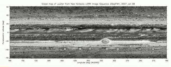
English: The Long Range Reconnaissance Imager (LORRI) on New Horizons has acquired six global maps of Jupiter as the spacecraft approaches the giant planet for a close encounter at the end of February. The high-resolution camera acquired each of six observation "sets" as a series of individual pictures taken one hour apart, covering a full 10-hour rotation of Jupiter. The LORRI team at the Johns Hopkins University Applied Physics Laboratory (APL) reduced the sets to form six individual maps in a simple rectangular projection. These six maps were then combined to make the movie.
The table below shows the dates and the ranges from Jupiter at which these six sets of observations were acquired. Even for the latest set of images taken January 21-22, from 60.5 million kilometers (37.6 million miles), New Horizons was still farther from Jupiter than the average distance of Mercury from the Sun. At that distance from Jupiter, a single LORRI picture resolution element amounts to 300 kilometers (186 miles) on Jupiter. Many features seen in Jupiter's atmosphere are giant storm clouds. The Little Red Spot, which LORRI will image close-up on February 27, is the target-like feature located near 30 degrees South and 230 degrees West; this storm is larger than the Earth. The even larger Great Red Spot is seen near 20 degrees South and 320 degrees West. The counterclockwise rotation of the clouds within the Great Red Spot can be seen. The westward drift of the Great Red Spot is easily seen in the movie, as is the slower drift, in the opposite direction, of the Little Red Spot. The storms of Jupiter are not fixed in location relative to each other or relative to any solid surface below, because Jupiter is a fluid planet without a solid surface. Also, dramatic changes are seen in the series of bright plume-like clouds encircling the planet between 0 and 10 degrees North. Scientists believe these result from an enormous atmospheric wave with rising air, rich in ammonia that condenses to form the plume tails, and with falling air in the dark areas just to the east of each plume. The maps of Jupiter shown here do not include the polar regions, because those regions are not well seen by LORRI from its vantage point high above Jupiter's equatorial region. Shadows of Jupiter's moons (first of Io, then of Ganymede) appear in two of the maps. |
| Date | (published) |
| Source | Catalog page · Full-res (GIF) |
| Author | NASA/Johns Hopkins University Applied Physics Laboratory/Southwest Research Institute |
This image or video was catalogued by Jet Propulsion Laboratory of the United States National Aeronautics and Space Administration (NASA) under Photo ID: PIA09242. This tag does not indicate the copyright status of the attached work. A normal copyright tag is still required. See Commons:Licensing. Other languages:
|
 |
This media is a product of the New Horizons mission Credit and attribution belongs to the Long-Range Reconnaissance Imager (LORRI) team, NASA/Johns Hopkins University Applied Physics Laboratory/Southwest Research Institute |
Licensing[edit]
.gif&action=edit§ion=2)
| This file is in the public domain in the United States because it was solely created by NASA. NASA copyright policy states that "NASA material is not protected by copyright unless noted". (See Template:PD-USGov, NASA copyright policy page or JPL Image Use Policy.) | ||
 |
Warnings:
|
File history
Click on a date/time to view the file as it appeared at that time.
| Date/Time | Thumbnail | Dimensions | User | Comment | |
|---|---|---|---|---|---|
| current | 17:19, 21 January 2017 | 648 × 256 (669 KB) | PhilipTerryGraham (talk | contribs) | User created page with UploadWizard |
You cannot overwrite this file.
File usage on Commons
The following 2 pages use this file:
.gif&redirect=no)
.gif&oldid=814958824)