File:Oxford Shire - By H. Moll Geographer - btv1b53056541t.jpg

Original file (2,936 × 4,096 pixels, file size: 1.83 MB, MIME type: image/jpeg)
Captions
Captions
Summary[edit]
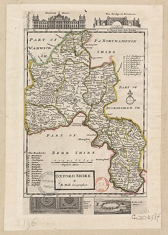
| English: Oxford Shire by Herman Moll Geographer
( |
|||||||||||||||||||||||||||
|---|---|---|---|---|---|---|---|---|---|---|---|---|---|---|---|---|---|---|---|---|---|---|---|---|---|---|---|
| Author |
|
||||||||||||||||||||||||||
| Title |
English: Oxford Shire by Herman Moll Geographer |
||||||||||||||||||||||||||
| Description |
English: Moll's map of Oxfordshire, sold separately and as Map 15 in his Set of Fifty New and Correct Maps of England and Wales... Illustrations in the margins of Blenheim Palace, the Grand Bridge in Blenheim Great Park, the Stonesfield Mosaic, and dolmens.
Français : Sujet : Antiquités romaines
Mosaïque antique Châteaux Divisions politiques et administratives Oxford, Comté d' -- Divisions politiques et administratives Woodstock Rollright Stones (site archéologique) Blenheim, Château de Échelle(s) : 10 English Miles [= 6 cm] Référence bibliographique : 173 Appartient à l’ensemble documentaire : AnvilEur Appartient à l’ensemble documentaire : MAEDI008 Appartient à l’ensemble documentaire : MAEDIGen0 Couverture : Royaume-Uni – Angleterre – Oxfordshire Langue : anglais Éditeur : [T. Bowles] (London) |
||||||||||||||||||||||||||
| Date | 1724 | ||||||||||||||||||||||||||
| Dimensions | height: 23 cm (9 in); width: 33.5 cm (13.1 in) | ||||||||||||||||||||||||||
| Collection |
|
||||||||||||||||||||||||||
| References |
Français : Notice de recueil : http://catalogue.bnf.fr/ark:/12148/cb40577015h
Appartient à : Collection d'Anville ; 02196 Notice du catalogue : http://catalogue.bnf.fr/ark:/12148/cb412476155 Extrait de A New Description of England and Wales, With the Adjacent Islands, 1724. |
||||||||||||||||||||||||||
| Source/Photographer |
Français : Bibliothèque nationale de France, département Cartes et plans, GE DD-2987 (2196)
Bibliothèque nationale de France |
||||||||||||||||||||||||||
| Permission (Reusing this file) |
|
||||||||||||||||||||||||||
| Other versions |
|
||||||||||||||||||||||||||


| Annotations | This image is annotated: View the annotations at Commons |
File history
Click on a date/time to view the file as it appeared at that time.
| Date/Time | Thumbnail | Dimensions | User | Comment | |
|---|---|---|---|---|---|
| current | 14:39, 22 July 2022 | | 2,936 × 4,096 (1.83 MB) | Gzen92Bot (talk | contribs) | Gallica btv1b53056541t |
You cannot overwrite this file.
File usage on Commons
The following 5 pages use this file: