File:OttomanEmpireIn1683tr.png
Jump to navigation
Jump to search
Size of this preview: 637 × 599 pixels. Other resolutions: 255 × 240 pixels | 510 × 480 pixels | 816 × 768 pixels | 1,088 × 1,024 pixels | 1,966 × 1,850 pixels.
Original file (1,966 × 1,850 pixels, file size: 327 KB, MIME type: image/png)
Captions
Captions
Add a one-line explanation of what this file represents
Summary[edit]
| Description |
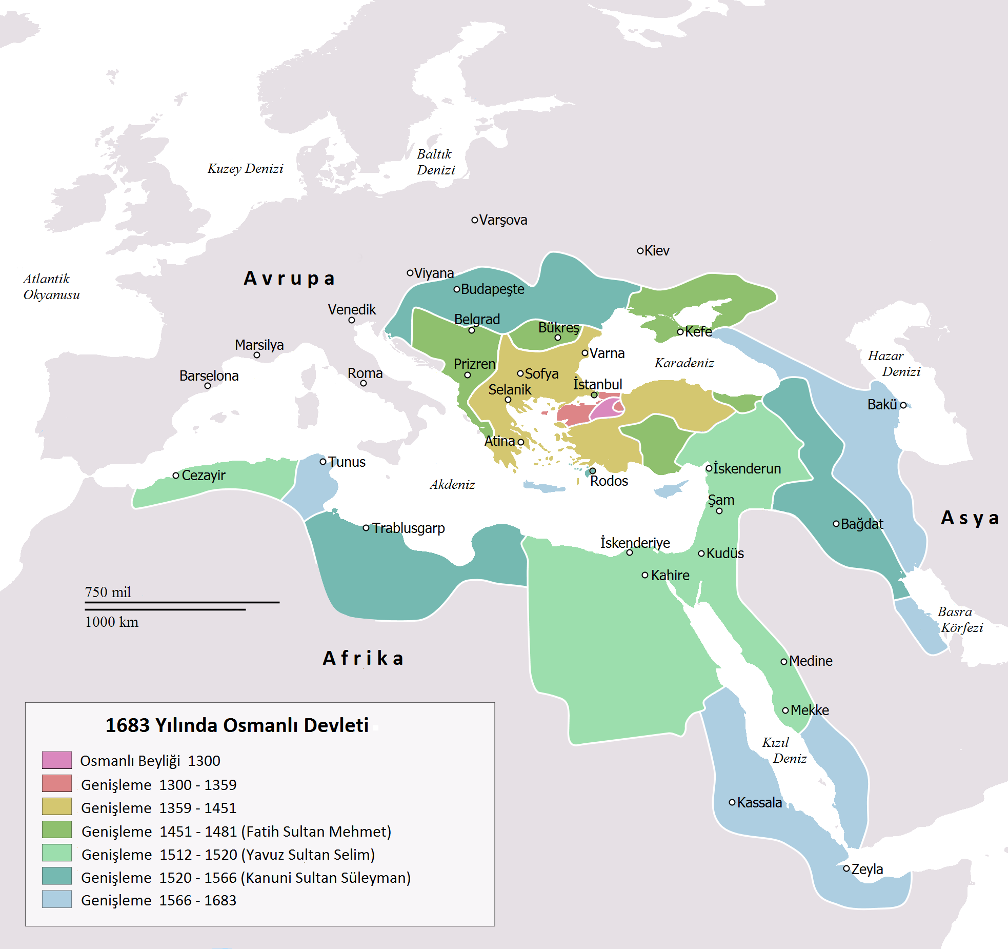
English: Map depicting the Ottoman Empire at its greatest extent, in 1683.
Türkçe: 1683 yılına gelindiğinde Osmanlı İmparatorluğu haritası |
| Date | |
| Source | Self drawn, mainly based on Robert Mantran (ed.), Histoire de l'Empire Ottoman, Paris: Fayard (1989), also en:List of Ottoman Empire dominated territories, Image:Ottoman 1683.png, [1], and [2]. Background map modified from Image:A large blank world map with oceans marked in blue.svg. |
| Author | Atilim Gunes Baydin yapımı, Osmanlı98 Türkçeye çevirdi. |
| Other versions |
[]
|


![[1]](http://fs.huntingdon.edu/jlewis/Syl/IRcomp/Maps/OttomanMap.jpg)
![[2]](http://www.morainevalley.edu/ctl/MiddleEast/images/Map_Ottoman_Empire_expansion_EB.jpg)
Licensing[edit]
| I, the copyright holder of this work, release this work into the public domain. This applies worldwide. In some countries this may not be legally possible; if so: I grant anyone the right to use this work for any purpose, without any conditions, unless such conditions are required by law. |
File history
Click on a date/time to view the file as it appeared at that time.
| Date/Time | Thumbnail | Dimensions | User | Comment | |
|---|---|---|---|---|---|
| current | 22:15, 14 November 2016 | | 1,966 × 1,850 (327 KB) | Gündoğdu (talk | contribs) | New version.High image quality |
| 16:23, 28 February 2010 |  | 637 × 599 (101 KB) | Osmanlı98 (talk | contribs) | Cezayir=Trablus | |
| 13:04, 7 February 2010 |  | 637 × 599 (100 KB) | Osmanlı98 (talk | contribs) | {{Information |Description={{en|1=Map depicting the Ottoman Empire at its greatest extent, in 1683.}} {{tr|1=1683 yılına gelindiğinde Osmanlı İmparatorluğu haritası}} |Source=Self drawn, mainly based on ''Robert Mantran (ed.), Histoire de l'Empire |
You cannot overwrite this file.
File usage on Commons
The following 11 pages use this file:
- User:J budissin/Uploads/BiH/2016 November 11-20
- File:Japanese-Ottoman1683.PNG
- File:OttomanEmpireIn1683-cy.svg
- File:OttomanEmpireIn1683-fr.svg
- File:OttomanEmpireIn1683-wl.png
- File:OttomanEmpireIn1683-zh-classical.png
- File:OttomanEmpireIn1683-zh-hans.svg
- File:OttomanEmpireIn1683.png
- File:OttomanEmpireIn1683 ar.png
- File:OttomanEmpireIn1683tr.png
- Template:Other Versions/OttomanEmpireIn1683
File usage on other wikis
The following other wikis use this file:
- Usage on az.wikipedia.org
- Usage on tr.wikipedia.org
- Usage on ug.wikipedia.org