File:Orientation map with 'Mute Signs'.jpg
Jump to navigation
Jump to search
Size of this preview: 800 × 372 pixels. Other resolutions: 320 × 149 pixels | 640 × 298 pixels | 1,376 × 640 pixels.
Original file (1,376 × 640 pixels, file size: 530 KB, MIME type: image/jpeg)
Captions
Captions
Add a one-line explanation of what this file represents
Summary[edit]
| Description |
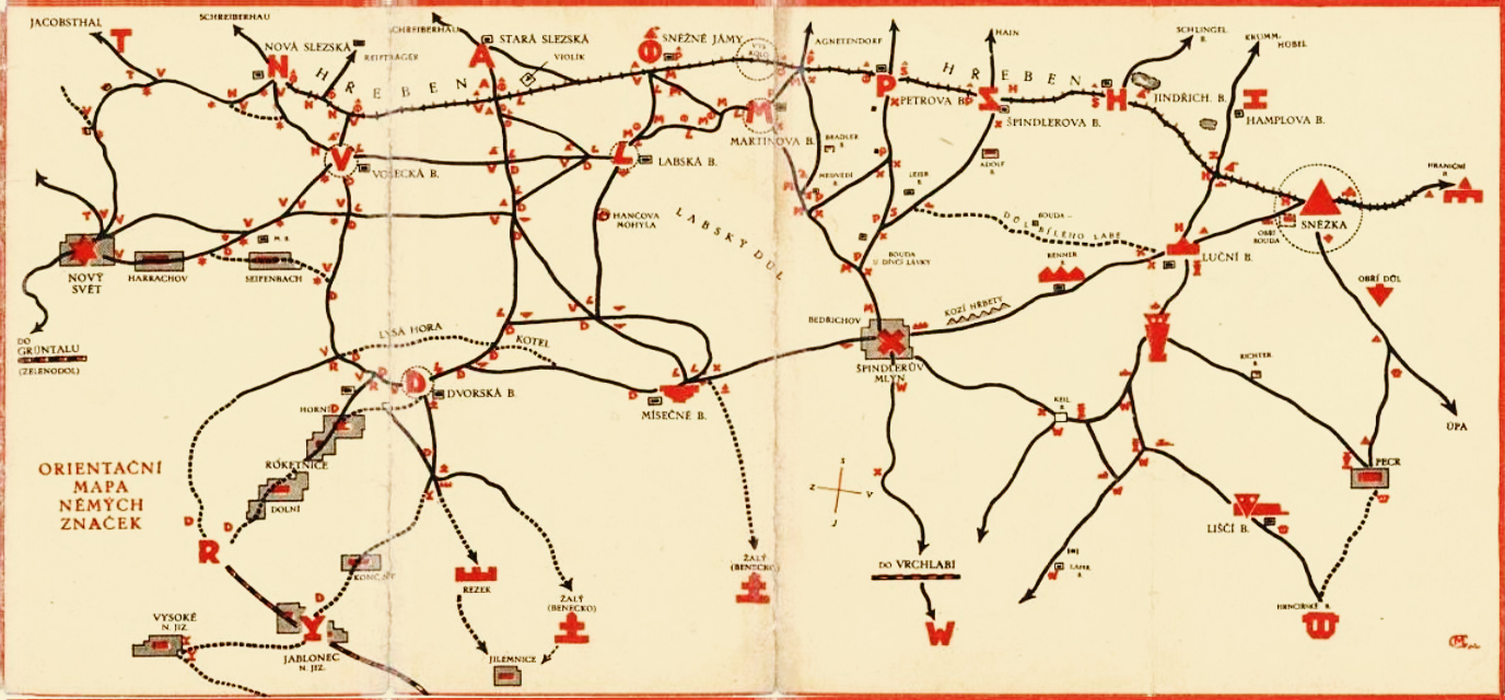
Čeština: Orientační mapa s „Němé Znamení“ Deutsch: Orientierungskarte mit „Stummen Zeichen“ English: Orientation map with "Mute Signs" Français : Carte d'orientation avec « Signes Muets » |
| Date | before 1924 |
| Source | http://docplayer.cz/46320567-Revitalizace-muttichovych-znacek.html |
| Author | Kamil Vladislav Muttich (1873–1924) |
| This is a retouched picture, which means that it has been digitally altered from its original version. Modifications: Sättigung verringert und leicht aufgehellt; Bildzuschnitt (Vielfaches von 16 px), Photoshop Speicheroptionen: Qualität 12. Modifications made by MagentaGreen.
|
Licensing[edit]
|
This work is in the public domain in its country of origin and other countries and areas where the copyright term is the author's life plus 70 years or fewer. This work is in the public domain in the United States because it was published (or registered with the U.S. Copyright Office) before January 1, 1929. | |
| This file has been identified as being free of known restrictions under copyright law, including all related and neighboring rights. | |
File history
Click on a date/time to view the file as it appeared at that time.
| Date/Time | Thumbnail | Dimensions | User | Comment | |
|---|---|---|---|---|---|
| current | 14:03, 20 October 2017 | | 1,376 × 640 (530 KB) | MagentaGreen (talk | contribs) | =={{int:filedesc}}== {{Information |description={{cs|Orientační mapa s „Němé Znamení“}}{{de|Orientierungskarte mit „Stummen Zeichen“}}{{en|Orientation map with "Mute Signs"}}{{fr|Carte d'orientation avec « Signes Muets »}} |date={{other... |
You cannot overwrite this file.
File usage on Commons
There are no pages that use this file.
File usage on other wikis
The following other wikis use this file:
- Usage on cs.wikipedia.org
- Usage on de.wikipedia.org