File:Olton railway station photo-survey (14) - geograph.org.uk - 1528520.jpg
Original file (462 × 640 pixels, file size: 111 KB, MIME type: image/jpeg)
Captions
Captions
Summary[edit]
_-_geograph.org.uk_-_1528520.jpg&action=edit§ion=1)
| Description |
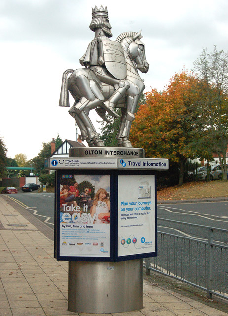
English: Olton railway station photo-survey (14) This statue greets passengers arriving at Olton railway station. The relevance of a child-like caricature of an armour-wearing horseman at a railway and bus interchange is unclear: no doubt it has some local significance. For a wider view of the statue's location see [1] .
Olton station is on the ex-GWR (Great western Railway) London to Birmingham line. It serves the suburbs of Olton and Ulverley Green about six miles east-southeast of Birmingham city centre. The line was originally built with double track and Olton station had two facing platforms, one either side of the two through lines. However, in the early 1930s the GWR quadrupled the track in the Birmingham area to cope with greatly increased suburban traffic. After quadrupling, Olton station had two island platforms, one serving the two down lines, the other serving the two up lines. Today, the route is reduced to two tracks again and one of Olton's 1930s island platforms (the one on the east side of the site) serves the up and down lines. The other island platform is no longer accessible and is very overgrown. Olton station is operated by London Midland as part of Network West Midlands and is a designated rail/bus interchange point. The majority of train services are operated by London midland but some Chiltern Railways trains call at Olton. |
| Date | |
| Source | From geograph.org.uk |
| Author | Andy F |
| Attribution (required by the license) | Andy F / Olton railway station photo-survey (14) / |
| Camera location | | View this and other nearby images on: OpenStreetMap |
|---|
_-_geograph.org.uk_-_1528520.jpg¶ms=052.438200_N_-001.805600_E_globe:Earth_type:camera_source:geograph-osgb36(SP13318226)_heading:90.00&language=en)
| Object location | | View this and other nearby images on: OpenStreetMap |
|---|
_-_geograph.org.uk_-_1528520.jpg¶ms=052.438200_N_-001.805000_E_globe:Earth_class:object_type:object_source:geograph-osgb36(SP13358226)_heading:90.00&language=en)
Licensing[edit]
_-_geograph.org.uk_-_1528520.jpg&action=edit§ion=2)

|
This image was taken from the Geograph project collection. See this photograph's page on the Geograph website for the photographer's contact details. The copyright on this image is owned by Andy F and is licensed for reuse under the Creative Commons Attribution-ShareAlike 2.0 license.
|
- You are free:
- to share – to copy, distribute and transmit the work
- to remix – to adapt the work
- Under the following conditions:
- attribution – You must give appropriate credit, provide a link to the license, and indicate if changes were made. You may do so in any reasonable manner, but not in any way that suggests the licensor endorses you or your use.
- share alike – If you remix, transform, or build upon the material, you must distribute your contributions under the same or compatible license as the original.
File history
Click on a date/time to view the file as it appeared at that time.
| Date/Time | Thumbnail | Dimensions | User | Comment | |
|---|---|---|---|---|---|
| current | 03:52, 3 March 2011 | | 462 × 640 (111 KB) | GeographBot (talk | contribs) | == {{int:filedesc}} == {{Information |description={{en|1=Olton railway station photo-survey (14) This statue greets passengers arriving at Olton railway station. The relevance of a child-like caricature of an armour-wearing horseman at a railway and bus i |
You cannot overwrite this file.
File usage on Commons
The following page uses this file:
File usage on other wikis
The following other wikis use this file:
- Usage on en.wikipedia.org
- Usage on pl.wikipedia.org
- Usage on www.wikidata.org
_-_geograph.org.uk_-_1528520.jpg&oldid=717710609)