File:Old road sign above Crosscleuch Burn - geograph.org.uk - 1542737.jpg
Jump to navigation
Jump to search

Size of this preview: 450 × 600 pixels. Other resolutions: 180 × 240 pixels | 480 × 640 pixels.
Original file (480 × 640 pixels, file size: 91 KB, MIME type: image/jpeg)
Captions
Captions
Add a one-line explanation of what this file represents
Summary[edit]
| Description |
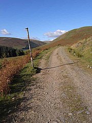
English: Old road sign above Crosscleuch Burn An old road, long abandoned for motor traffic, runs from Berrybush on the B709 down to the Tibbie Shiels Inn. I travelled this road in the 1950s, and it was in a poor state even then. On that occasion, I saw a rare sight - a road sign erected by the CTC (Cyclists' Touring Club). This post obviously once supported a road sign - possibly the very one.
The road is now followed by the Southern Uplands Way. |
| Date | |
| Source | From geograph.org.uk |
| Author | Oliver Dixon |
| Attribution (required by the license) | Oliver Dixon / Old road sign above Crosscleuch Burn / |
| Camera location | | View this and other nearby images on: OpenStreetMap |
|---|
_heading:0.00&language=en)
| Object location | | View this and other nearby images on: OpenStreetMap |
|---|
_heading:0.00&language=en)
Licensing[edit]

|
This image was taken from the Geograph project collection. See this photograph's page on the Geograph website for the photographer's contact details. The copyright on this image is owned by Oliver Dixon and is licensed for reuse under the Creative Commons Attribution-ShareAlike 2.0 license.
|
This file is licensed under the Creative Commons Attribution-Share Alike 2.0 Generic license.
Attribution: Oliver Dixon
- You are free:
- to share – to copy, distribute and transmit the work
- to remix – to adapt the work
- Under the following conditions:
- attribution – You must give appropriate credit, provide a link to the license, and indicate if changes were made. You may do so in any reasonable manner, but not in any way that suggests the licensor endorses you or your use.
- share alike – If you remix, transform, or build upon the material, you must distribute your contributions under the same or compatible license as the original.
File history
Click on a date/time to view the file as it appeared at that time.
| Date/Time | Thumbnail | Dimensions | User | Comment | |
|---|---|---|---|---|---|
| current | 10:25, 3 March 2011 | | 480 × 640 (91 KB) | GeographBot (talk | contribs) | == {{int:filedesc}} == {{Information |description={{en|1=Old road sign above Crosscleuch Burn An old road, long abandoned for motor traffic, runs from Berrybush on the B709 down to the Tibbie Shiels Inn. I travelled this road in the 1950s, and it was in a |
You cannot overwrite this file.
File usage on Commons
There are no pages that use this file.