File:Old baton rouge.jpg
Jump to navigation
Jump to search

Size of this preview: 750 × 600 pixels. Other resolutions: 300 × 240 pixels | 600 × 480 pixels | 960 × 768 pixels | 1,280 × 1,024 pixels | 1,440 × 1,152 pixels.
Original file (1,440 × 1,152 pixels, file size: 193 KB, MIME type: image/jpeg)
Captions
Captions
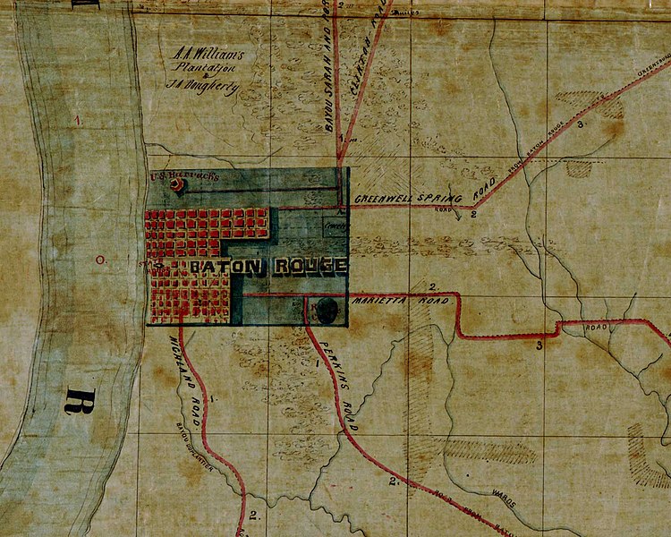
Map of old Baton Rouge - Detail from "Map of the region east and north of Baton Rouge, showing batteries on the Mississippi north of Port Hudson".
Summary[edit]
Map of old Baton Rouge. Detail from "Map of the region east and north of Baton Rouge, showing batteries on the Mississippi north of Port Hudson". According to the Library of Congress catalog entry, the creation date of the map is "1863?"; that is, this date is probable but not certain.
Original work[edit]
http://hdl.loc.gov/loc.gmd/g4014b.cw1007000
Licensing[edit]
This work is in the public domain in the United States because it is a work prepared by an officer or employee of the United States Government as part of that person’s official duties under the terms of Title 17, Chapter 1, Section 105 of the US Code.
Note: This only applies to original works of the Federal Government and not to the work of any individual U.S. state, territory, commonwealth, county, municipality, or any other subdivision. This template also does not apply to postage stamp designs published by the United States Postal Service since 1978. (See § 313.6(C)(1) of Compendium of U.S. Copyright Office Practices). It also does not apply to certain US coins; see The US Mint Terms of Use.
|
 | |
| This file has been identified as being free of known restrictions under copyright law, including all related and neighboring rights. | ||

|
This map is available from the United States Library of Congress's Geography & Map Division
under the digital ID g4014b.cw1007000. This tag does not indicate the copyright status of the attached work. A normal copyright tag is still required. See Commons:Licensing.
|
File history
Click on a date/time to view the file as it appeared at that time.
| Date/Time | Thumbnail | Dimensions | User | Comment | |
|---|---|---|---|---|---|
| current | 02:32, 16 August 2007 | | 1,440 × 1,152 (193 KB) | Kkmurray (talk | contribs) | Map of old Baton Rouge. Detail from "Map of the region east and north of Baton Rouge, showing batteries on the Mississippi north of Port Hudson". ==Original work== http://hdl.loc.gov/loc.gmd/g4014b.cw1007000 [Map of the region east and north of Baton |
You cannot overwrite this file.
File usage on Commons
The following page uses this file:
File usage on other wikis
The following other wikis use this file:
- Usage on en.wikipedia.org
- Usage on he.wikipedia.org
- Usage on it.wikipedia.org