File:Old South Jacksonville City Hall.jpeg
Jump to navigation
Jump to search
Size of this preview: 800 × 450 pixels. Other resolutions: 320 × 180 pixels | 640 × 360 pixels | 1,024 × 576 pixels | 1,280 × 720 pixels | 2,560 × 1,440 pixels | 4,160 × 2,340 pixels.
Original file (4,160 × 2,340 pixels, file size: 3.69 MB, MIME type: image/jpeg)
Captions
Captions
Add a one-line explanation of what this file represents
Summary[edit]
| Description |
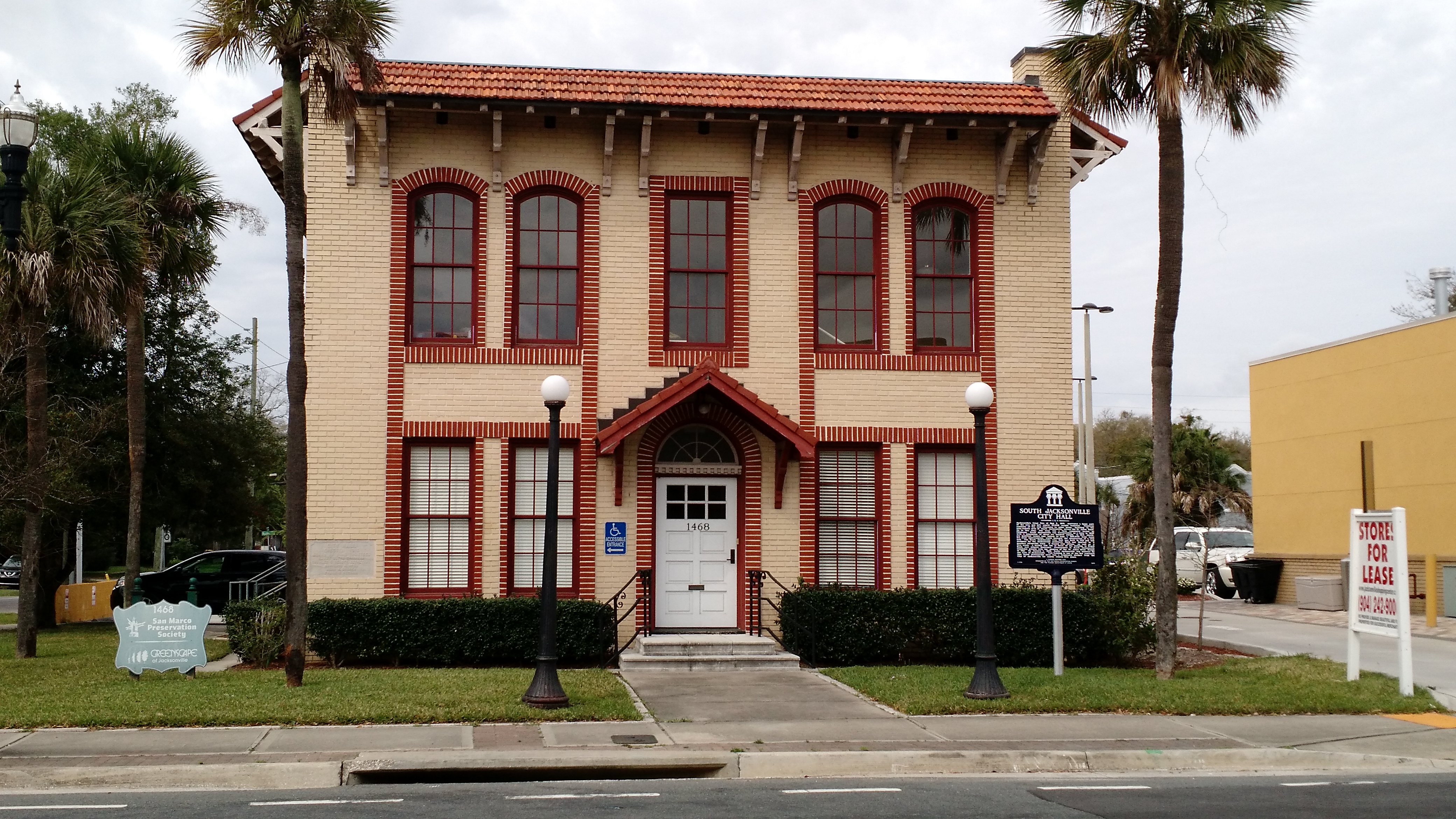
English: Sign reads: Jacksonville's Great Fire of May 3, 1901, destroyed a large part of the city and left nearly 10,000 people homeless. Numerous residents of the city relocated to other areas, including to the then-remote area of South Jacksonville, across the St. John's River. Up to this time, this area was a farm community known as Oklahoma. South Jacksonville was incorporated as a town in 1907 with a population of about six hundred people. In 1913, ninety-six qualified voters cast ballots to pass a $65,000 bond issue Cor civic improvements, which included the construction of a city hall. The South Jacksonville City Hall was built in 1915 and was designed by the Jacksonville architects Mark and Sheftall in a masonry vernacular style. It housed city offices, as well as a fire truck. A trolley line ran in front of the building to Beach Road, now Atlantic Boulevard. Development in South Jacksonville expanded greatly with the opening of the St. John's River Bridge in 1921. On January 1, 1932, South Jacksonville was annexed by the City of Jacksonville. This building is one of the few reminders that South Jacksonville once was a community distinct from the City of Jacksonville for nearly twenty-five years.
Español: El Gran fuego de Jacksonville, 3 mayo, 1901, destruyó una gran parte de la ciudad y dejó cerca de 10.000 sin hogar. Numerosos vecinos de la ciudad reubicados a otras áreas, incluyendo a la zona de sur de Jacksonville, a través del Río St. John. Hasta aquella momento, la área era una comunidad agrícola conocido como Oklahoma. South Jacksonville fue incorporada como ciudad en 1907 con una población de alrededor de seiscientas personas. En 1913, noventa y seis votantes calificados votaron para aprobar una emisión de bonos de $65.000 por mejoras cívicas, que incluía la construcción de un ayuntamiento. El ayuntamiento de South Jacksonville fue construido en 1915 y fue diseñado por arquitectos Mark y Sheftall, de Jacksonville, en un estilo mampostería vernáculo. El ayuntamiento albergaba oficinas de la ciudad, así como un camión de bomberos. Una línea de tranvías corrió delante del edificio a Beach Road, ahora Atlantic Boulevard. El desarrollo en South Jacksonville ampliado en gran medida con la apertura del Puente de Río St. John en 1921. El 1 enero, 1932, South Jacksonville fue anexado por la ciudad de Jacksonville. Este edificio es uno de los pocos recordatorios que South Jacksonville una vez era comunidad distinta de la ciudad de Jacksonville durante cerca de veinte y cinco años. |
| Date | |
| Source | Own work |
| Author | Timdwilliamson |
| Camera location | | View this and other nearby images on: OpenStreetMap |
|---|
Google Maps link This building is located in the San Marco district of Jacksonville.
Licensing[edit]
I, the copyright holder of this work, hereby publish it under the following license:
This file is licensed under the Creative Commons Attribution-Share Alike 4.0 International license.
- You are free:
- to share – to copy, distribute and transmit the work
- to remix – to adapt the work
- Under the following conditions:
- attribution – You must give appropriate credit, provide a link to the license, and indicate if changes were made. You may do so in any reasonable manner, but not in any way that suggests the licensor endorses you or your use.
- share alike – If you remix, transform, or build upon the material, you must distribute your contributions under the same or compatible license as the original.
File history
Click on a date/time to view the file as it appeared at that time.
| Date/Time | Thumbnail | Dimensions | User | Comment | |
|---|---|---|---|---|---|
| current | 03:04, 23 March 2016 | | 4,160 × 2,340 (3.69 MB) | Timdwilliamson (talk | contribs) | User created page with UploadWizard |
You cannot overwrite this file.
File usage on Commons
There are no pages that use this file.