File:Ok-6 path.png
Jump to navigation
Jump to search

Size of this preview: 800 × 463 pixels. Other resolutions: 320 × 185 pixels | 640 × 371 pixels | 1,024 × 593 pixels | 1,280 × 741 pixels | 3,507 × 2,031 pixels.
Original file (3,507 × 2,031 pixels, file size: 1.15 MB, MIME type: image/png)
Captions
Captions
Add a one-line explanation of what this file represents
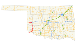
| Description | A map showing the path of State Highway 6 in Oklahoma. |
| Date | |
| Source | Created by me in Quantum GIS 0.8.0 based on data collected from http://www.geo.ou.edu/. |
| Author | Scott5114 |
| I, the copyright holder of this work, release this work into the public domain. This applies worldwide. In some countries this may not be legally possible; if so: I grant anyone the right to use this work for any purpose, without any conditions, unless such conditions are required by law. |
File history
Click on a date/time to view the file as it appeared at that time.
| Date/Time | Thumbnail | Dimensions | User | Comment | |
|---|---|---|---|---|---|
| current | 23:28, 26 April 2012 | | 3,507 × 2,031 (1.15 MB) | Scott5114 (talk | contribs) | zoom out to show entire state |
| 08:10, 9 August 2007 |  | 1,435 × 1,010 (175 KB) | Scott5114 (talk | contribs) | Crop | |
| 08:06, 9 August 2007 |  | 1,489 × 1,240 (191 KB) | Scott5114 (talk | contribs) | {{Information |Description=A map showing the path of State Highway 6 in Oklahoma. |Source=Created by me in Quantum GIS 0.8.0 based on data collected from http://www.geo.ou.edu/. |Date=2007-08-09 |Author= [[User:Scott51 |
You cannot overwrite this file.
File usage on Commons
The following 2 pages use this file:
File usage on other wikis
The following other wikis use this file:
- Usage on www.wikidata.org