File:Ohrid and Prespa lakes topographic map-HE.svg
Jump to navigation
Jump to search

Size of this PNG preview of this SVG file: 689 × 599 pixels. Other resolutions: 276 × 240 pixels | 552 × 480 pixels | 883 × 768 pixels | 1,177 × 1,024 pixels | 2,354 × 2,048 pixels | 692 × 602 pixels.
Original file (SVG file, nominally 692 × 602 pixels, file size: 4.82 MB)
Captions
Captions
Add a one-line explanation of what this file represents
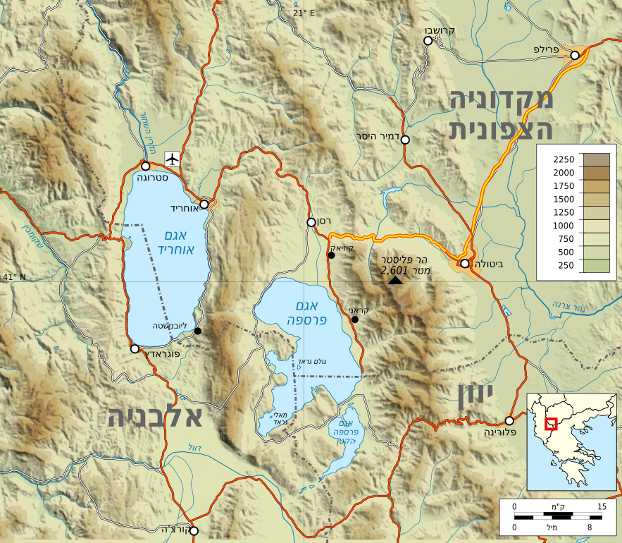
| Description | Ohrid and Prespa lakes topographic map HE |
| Date | |
| Source | Own work based on: Ohrid and Prespa lakes topographic map.svg |
| Author | Ori~ |
| Other versions |
I, the copyright holder of this work, hereby publish it under the following license: This file is licensed under the Creative Commons Attribution-Share Alike 3.0 Unported license.
|
| SVG development |
File history
Click on a date/time to view the file as it appeared at that time.
| Date/Time | Thumbnail | Dimensions | User | Comment | |
|---|---|---|---|---|---|
| current | 10:12, 25 July 2020 | | 692 × 602 (4.82 MB) | רונאלדיניו המלך (talk | contribs) | מקדוניה->מקדוניה הצפונית |
| 10:07, 25 July 2020 |  | 692 × 602 (4.82 MB) | Matankic (talk | contribs) | Reverted to version as of 08:00, 23 June 2010 (UTC) | |
| 10:01, 25 July 2020 |  | 692 × 602 (4.82 MB) | Matankic (talk | contribs) | m | |
| 09:59, 25 July 2020 |  | 692 × 602 (4.82 MB) | Matankic (talk | contribs) | מקדוניה->מקדוניה הצפונית | |
| 08:00, 23 June 2010 |  | 692 × 602 (4.82 MB) | Ori~ (talk | contribs) | ed | |
| 07:56, 23 June 2010 |  | 692 × 602 (4.82 MB) | Ori~ (talk | contribs) | {{Information |Description=Ohrid and Prespa lakes topographic map HE |Source={{own}} after File:Ohrid and Prespa lakes topographic map.svg |Date=2010-06-22 |Author= Ori~ |Permission= |other_versions={{self|cc-by-sa-3.0}} }} [[Category:L |
You cannot overwrite this file.
File usage on Commons
The following 2 pages use this file:
File usage on other wikis
The following other wikis use this file:
- Usage on he.wikipedia.org