File:Ohio population map.png
Jump to navigation
Jump to search
No higher resolution available.
Ohio_population_map.png (600 × 600 pixels, file size: 172 KB, MIME type: image/png)
Captions
Captions
Add a one-line explanation of what this file represents
Summary[edit]
Taken from the English Wikipedia.
Original Description:
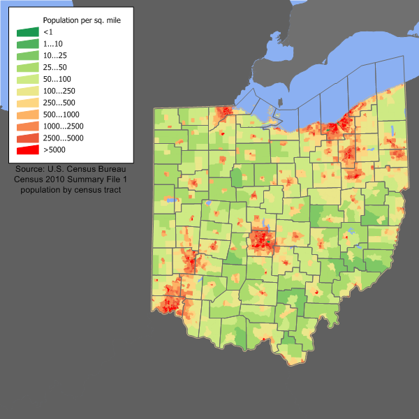
Ohio population density map based on Census 2010 data. See the data lineage for the process description.
Original History:
20:16, 5 March 2006 . . JimIrwin (Talk) . . 672x550 (40783 bytes) (Ohio population density map based on Census 2000 data. See the data lineage for the process description.)
Licensing[edit]
JimIrwin at the English-language Wikipedia, the copyright holder of this work, hereby publishes it under the following license:

|
Permission is granted to copy, distribute and/or modify this document under the terms of the GNU Free Documentation License, Version 1.2 or any later version published by the Free Software Foundation; with no Invariant Sections, no Front-Cover Texts, and no Back-Cover Texts. A copy of the license is included in the section entitled GNU Free Documentation License. |
| This file is licensed under the Creative Commons Attribution-Share Alike 3.0 Unported license. | ||
| Attribution: JimIrwin | ||
| ||
| This licensing tag was added to this file as part of the GFDL licensing update. |
File history
Click on a date/time to view the file as it appeared at that time.
| Date/Time | Thumbnail | Dimensions | User | Comment | |
|---|---|---|---|---|---|
| current | 14:29, 11 December 2011 | | 600 × 600 (172 KB) | JimIrwin (talk | contribs) | 2010 census update |
| 21:28, 10 April 2006 |  | 672 × 550 (40 KB) | Buckeye~commonswiki (talk | contribs) | Taken from the English Wikipedia.<br> Original Description:<br> ''Ohio population density map based on Census 2000 data. See the data lineage for the process description.''<br> Original History:<br> ''20:16 |
You cannot overwrite this file.
File usage on Commons
The following page uses this file:
File usage on other wikis
The following other wikis use this file:
- Usage on arz.wikipedia.org
- Usage on ca.wikipedia.org
- Usage on cy.wikipedia.org
- Usage on da.wikipedia.org
- Usage on de.wikipedia.org
- Usage on en.wikipedia.org
- Usage on es.wikipedia.org
- Usage on fi.wikipedia.org
- Usage on fr.wikipedia.org
- Usage on gl.wikipedia.org
- Usage on he.wikipedia.org
- Usage on hu.wikipedia.org
- Usage on incubator.wikimedia.org
- Usage on ja.wikipedia.org
- Usage on pt.wikipedia.org
- Usage on ro.wikipedia.org
- Categorie:Oameni din Ohio
- Categorie:Statul Ohio, SUA
- Ohio
- Drapelul statului Ohio
- Format:Ohio stat SUA
- Akron, Ohio
- Avon Lake, Ohio
- Categorie:Membri ai Senatului SUA din statul Ohio
- Categorie:Liste Ohio
- Categorie:Comitate din statul Ohio, SUA
- Râul Ohio
- Listă de oameni din statul Ohio
- Categorie:Guvernul statului Ohio
- Quincy, Ohio
- Categorie:Sedii de comitate din Ohio
- Berlin, comitatul Holmes, Ohio
- Comitatul Williams, Ohio
- Comitatul Holmes, Ohio
- Categorie:Comitatul Holmes, Ohio
- Categorie:Comitatul Washington, Ohio
- Listă de orașe din Ohio
- Comitatul Adams, Ohio
- Categorie:Zone metropolitane din Ohio
- Categorie:Zone micropolitane din Ohio
- Listă de comitate din statul Ohio
- Categorie:Comitatul Warren, Ohio
- Categorie:Comitatul Stark, Ohio
- Categorie:Comitatul Summit, Ohio
- Categorie:Comitatul Logan, Ohio
View more global usage of this file.