File:OffsetWGS84-ETRS89.svg
Jump to navigation
Jump to search

Size of this PNG preview of this SVG file: 629 × 500 pixels. Other resolutions: 302 × 240 pixels | 604 × 480 pixels | 966 × 768 pixels | 1,280 × 1,017 pixels | 2,560 × 2,035 pixels.
Original file (SVG file, nominally 629 × 500 pixels, file size: 44 KB)
Captions
Captions
Add a one-line explanation of what this file represents
Summary[edit]
| Description |
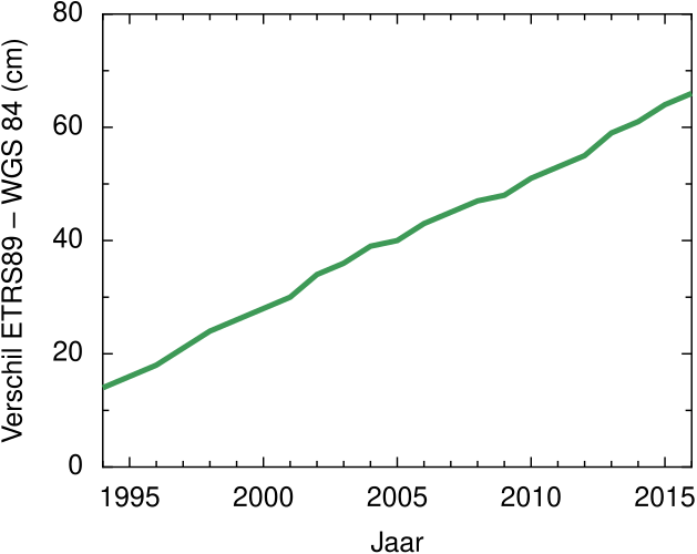
Nederlands: Verschil van representatieve positie in WGS84-realisatie, met positie met gelijke coördinaten in ETRS89-realisatie.
Bron: "Transformatieparameters tussen ITRS, WGS84 en ETRS89", https://www.defensie.nl/onderwerpen/hydrografie/documenten/circulaires/2010/08/23/transformatieparameters-tussen-itrs-wgs84-en-etrs89. De representatieve positie is: lat=53°N, lon=5°E, h=40m boven de ellipsoïde, ongeveer middenin het Nederlands territorium, inclusief het Nederlands continentaal plat, rond zeeniveau. |
| Date | |
| Source | Own work |
| Author | Cavit |
Licensing[edit]
I, the copyright holder of this work, hereby publish it under the following license:
This file is licensed under the Creative Commons Attribution 4.0 International license.
- You are free:
- to share – to copy, distribute and transmit the work
- to remix – to adapt the work
- Under the following conditions:
- attribution – You must give appropriate credit, provide a link to the license, and indicate if changes were made. You may do so in any reasonable manner, but not in any way that suggests the licensor endorses you or your use.
File history
Click on a date/time to view the file as it appeared at that time.
| Date/Time | Thumbnail | Dimensions | User | Comment | |
|---|---|---|---|---|---|
| current | 16:20, 13 November 2015 | | 629 × 500 (44 KB) | Cavit (talk | contribs) | Added space in WGS 84. Added white background. |
| 16:10, 13 November 2015 |  | 629 × 500 (44 KB) | Cavit (talk | contribs) | User created page with UploadWizard |
You cannot overwrite this file.
File usage on Commons
There are no pages that use this file.
File usage on other wikis
The following other wikis use this file:
- Usage on nl.wikipedia.org