File:Office europeen brevets.svg
Jump to navigation
Jump to search

Size of this PNG preview of this SVG file: 680 × 520 pixels. Other resolutions: 314 × 240 pixels | 628 × 480 pixels | 1,004 × 768 pixels | 1,280 × 979 pixels | 2,560 × 1,958 pixels.
Original file (SVG file, nominally 680 × 520 pixels, file size: 742 KB)
Captions
Captions
Add a one-line explanation of what this file represents
Summary[edit]
| Description |
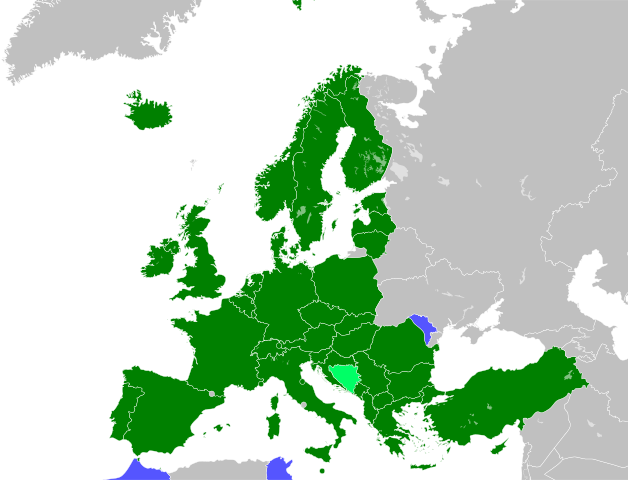
English: Map of the European Patent Organisation Contracting States, extension agreement states and validation agreement states.
Français : carte des membres de l'Office européen des brevets, les membres de plein droit ainsi que les états d'extension. |
| Date | 06/03/2010 |
| Source | Own work. Map taken from File:BlankMap-World6.svg |
| Author | Kyat02 |
Licensing[edit]
I, the copyright holder of this work, hereby publish it under the following licenses:

|
Permission is granted to copy, distribute and/or modify this document under the terms of the GNU Free Documentation License, Version 1.2 or any later version published by the Free Software Foundation; with no Invariant Sections, no Front-Cover Texts, and no Back-Cover Texts. A copy of the license is included in the section entitled GNU Free Documentation License. |
This file is licensed under the Creative Commons Attribution-Share Alike 3.0 Unported, 2.5 Generic, 2.0 Generic and 1.0 Generic license.
- You are free:
- to share – to copy, distribute and transmit the work
- to remix – to adapt the work
- Under the following conditions:
- attribution – You must give appropriate credit, provide a link to the license, and indicate if changes were made. You may do so in any reasonable manner, but not in any way that suggests the licensor endorses you or your use.
- share alike – If you remix, transform, or build upon the material, you must distribute your contributions under the same or compatible license as the original.
You may select the license of your choice.
File history
Click on a date/time to view the file as it appeared at that time.
| Date/Time | Thumbnail | Dimensions | User | Comment | |
|---|---|---|---|---|---|
| current | 10:45, 23 December 2022 | | 680 × 520 (742 KB) | Kyat02 (talk | contribs) | Montenegro is member since 2022 |
| 01:57, 12 December 2018 |  | 680 × 520 (741 KB) | Ratherous (talk | contribs) | Different colours for extensions and validations | |
| 02:43, 26 March 2018 |  | 680 × 520 (741 KB) | Forthrunner (talk | contribs) | Tunisia | |
| 22:42, 19 September 2017 |  | 680 × 520 (741 KB) | Growupon (talk | contribs) | Better map | |
| 06:22, 7 November 2015 |  | 145 × 135 (354 KB) | Jolly Janner (talk | contribs) | Using shade of green for consistency with File:Paris Convention for the Protection of Industrial Property.png and File:Patent Cooperation Treaty.png | |
| 20:46, 31 October 2015 |  | 146 × 136 (1.4 MB) | Jolly Janner (talk | contribs) | Added Moldova as a validation agreement coming into effect 1 Nov 2015. Also used a cropped version of Robinson projection map File:BlankMap-World6.svg to show all of Morocco. | |
| 22:27, 25 January 2015 |  | 680 × 520 (522 KB) | L.tak (talk | contribs) | + validation agreement for Morocco | |
| 17:58, 2 October 2010 |  | 680 × 520 (522 KB) | Kyat02 (talk | contribs) | {{Information |Description= version mise à jour |Source= OEB |Date= 01/10/2010 |Author= kyat02 |Permission= free licence |other_versions= }} | |
| 09:23, 4 June 2010 |  | 680 × 520 (522 KB) | Kyat02 (talk | contribs) | {{Information |Description= new version |Source= own work |Date= 04/06/2010 |Author= kyat02 |Permission= free licence |other_versions= }} | |
| 21:58, 6 March 2010 |  | 680 × 520 (522 KB) | Kyat02 (talk | contribs) | {{Information |Description={{en|1=map of the European Patent Organisation Contracting States and extension states}} {{fr|1=carte des membres de l'Office européen des brevets, les membres de plein droit ainsi que les états d'extension. }} |Source={{own}} |
You cannot overwrite this file.
File usage on Commons
There are no pages that use this file.
File usage on other wikis
The following other wikis use this file:
- Usage on ast.wikipedia.org
- Usage on bg.wikipedia.org
- Usage on da.wikipedia.org
- Usage on de.wikipedia.org
- Usage on en.wikipedia.org
- Usage on fr.wikipedia.org
- Usage on it.wikipedia.org
- Usage on nl.wikipedia.org
- Usage on pt.wikipedia.org
- Usage on ru.wikipedia.org
- Usage on vec.wikipedia.org
- Usage on www.wikidata.org