File:Oakland-Section map.jpg

Original file (1,460 × 1,000 pixels, file size: 513 KB, MIME type: image/jpeg)
Captions
Captions
Summary[edit]
|
This is an image of a place or building that is listed on the National Register of Historic Places in the United States of America. Its reference number is 76000627. |
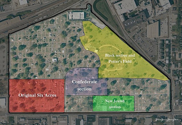
Aerial photograph of Oakland Cemetery created from public domain 2002 USGS survey data. Significant sections of the cemetery were shaded by on 2005-04-18. The map was stitched together from data obtained from TerraServer-USA. [1] Note that the boundaries drawn for the major sections of the cemetery are rough estimations. The history of Oakland is too complex to definitively draw boundaries, but the ones represented on the map reflect the sections as they are generally referenced by historians and cemetery caretakers.
A png version is availible at Image:Oakland-Section map.png please use that version to make changes to avoid unnessacery quality loss.
Licensing[edit]
- You are free:
- to share – to copy, distribute and transmit the work
- to remix – to adapt the work
- Under the following conditions:
- attribution – You must give appropriate credit, provide a link to the license, and indicate if changes were made. You may do so in any reasonable manner, but not in any way that suggests the licensor endorses you or your use.
| Object location | | View this and other nearby images on: OpenStreetMap |
|---|
File history
Click on a date/time to view the file as it appeared at that time.
| Date/Time | Thumbnail | Dimensions | User | Comment | |
|---|---|---|---|---|---|
| current | 16:11, 11 July 2005 | | 1,460 × 1,000 (513 KB) | Southgeist (talk | contribs) | Aerial photograph of Oakland Cemetery created from public domain 2002 USGS survey data. Significant sections of the cemetery were shaded by uberpenguin on 2005-04-18. The map was stitched together from data obtain |
You cannot overwrite this file.
File usage on Commons
The following page uses this file:
File usage on other wikis
The following other wikis use this file:
- Usage on de.wikipedia.org
- Usage on en.wikipedia.org