File:OKC wrongway.svg
Jump to navigation
Jump to search

Size of this PNG preview of this SVG file: 517 × 600 pixels. Other resolutions: 207 × 240 pixels | 414 × 480 pixels | 662 × 768 pixels | 883 × 1,024 pixels | 1,766 × 2,048 pixels | 638 × 740 pixels.
Original file (SVG file, nominally 638 × 740 pixels, file size: 261 KB)
Captions
Captions
Add a one-line explanation of what this file represents
Summary[edit]
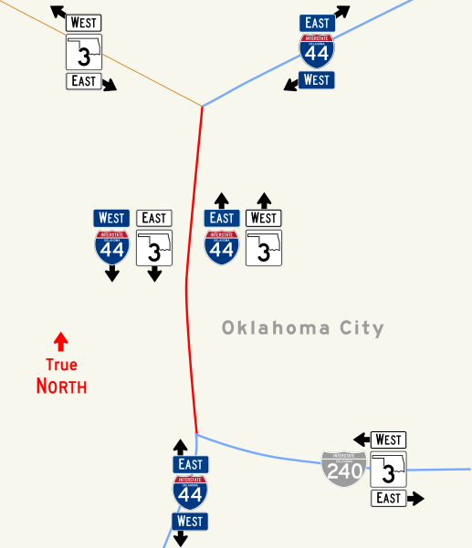
| Description | The Wrong-way concurrency in Oklahoma City, Oklahoma, United States. The red section highlights the concurrency. Map is not to scale (and probably inaccurate) and doesn't include irrelevant junctions. US 62 and OK 74 are omitted. |
| Date | |
| Source | self-made with other PD SVGs taken from Commons. |
| Author | Scott5114 |
| Permission (Reusing this file) |
Public domain. Credit appreciated but not required. |
Legend[edit]
| Roads | Borders | ||||||||||||||
|---|---|---|---|---|---|---|---|---|---|---|---|---|---|---|---|
|
|
Licensing[edit]
| I, the copyright holder of this work, release this work into the public domain. This applies worldwide. In some countries this may not be legally possible; if so: I grant anyone the right to use this work for any purpose, without any conditions, unless such conditions are required by law. |
File history
Click on a date/time to view the file as it appeared at that time.
| Date/Time | Thumbnail | Dimensions | User | Comment | |
|---|---|---|---|---|---|
| current | 23:03, 4 November 2007 | | 638 × 740 (261 KB) | Scott5114 (talk | contribs) | Extend lines off map, move north arrow onto the canvas fully |
| 23:02, 4 November 2007 |  | 638 × 740 (261 KB) | Scott5114 (talk | contribs) | {{Information |Description=The w:Wrong-way concurrency in Oklahoma City, Oklahoma, United States. The red section highlights the concurrency. Map is not to scale and doesn't include irrelevant junctions. US 62 and OK 74 are omitted. |Source=self-made |
You cannot overwrite this file.
File usage on Commons
The following page uses this file:
File usage on other wikis
The following other wikis use this file:
- Usage on en.wikipedia.org
- Usage on fr.wikipedia.org