File:O'Hara Township, Allegheny County, Pennsylvania, United States of America.png
Jump to navigation
Jump to search
No higher resolution available.
O'Hara_Township,_Allegheny_County,_Pennsylvania,_United_States_of_America.png (614 × 550 pixels, file size: 145 KB, MIME type: image/png)
Captions
Captions
Add a one-line explanation of what this file represents
Summary[edit]
| Description |
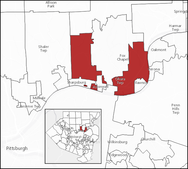
English: Map showing the five separate parts of O'Hara Township, including Sixmile Island in the Allegheny River. Source for Sixmile Island being in O'Hara Township is this USGS link.
Click this link, and after the map loads, click the box for the "Minor Civil Division labels" overlay, zoom in on Sixmile Island, wait for the data to finish "Loading", position the cursor on the island and double-click. It should display the word "O'Hara" on the island. (Or, just an extreme zoom-in without clicking should reveal it also.) Also, one may view the Allegheny County GIS map and again do an extreme zoom-in, the map changes to an aerial photograph of the island. Click on the island to bring up a text box that states,"Municipality: O'HARA Owner:TOWNSHIP OF O'HARA". |
| Date | |
| Source | Own work |
| Author | Jeff in CA |
Licensing[edit]
I, the copyright holder of this work, hereby publish it under the following license:
This file is licensed under the Creative Commons Attribution-Share Alike 4.0 International license.
- You are free:
- to share – to copy, distribute and transmit the work
- to remix – to adapt the work
- Under the following conditions:
- attribution – You must give appropriate credit, provide a link to the license, and indicate if changes were made. You may do so in any reasonable manner, but not in any way that suggests the licensor endorses you or your use.
- share alike – If you remix, transform, or build upon the material, you must distribute your contributions under the same or compatible license as the original.
File history
Click on a date/time to view the file as it appeared at that time.
| Date/Time | Thumbnail | Dimensions | User | Comment | |
|---|---|---|---|---|---|
| current | 17:45, 6 March 2016 | | 614 × 550 (145 KB) | Jeff in CA (talk | contribs) | slight crop on left side |
| 17:38, 6 March 2016 |  | 615 × 550 (145 KB) | Jeff in CA (talk | contribs) | better inset | |
| 19:53, 5 March 2016 |  | 615 × 550 (143 KB) | Jeff in CA (talk | contribs) | User created page with UploadWizard |
You cannot overwrite this file.
File usage on Commons
There are no pages that use this file.
File usage on other wikis
The following other wikis use this file:
- Usage on en.wikipedia.org