File:Nuevo mapa de la Republica Argentina (1914).png

Original file (4,719 × 7,535 pixels, file size: 51.97 MB, MIME type: image/png)
Captions
Captions
Summary[edit]
.png&action=edit§ion=1)
This is an intermediate version of the original DjVu graphic image file, uploaded in lossless format only for the purpose of editing.
| Description |
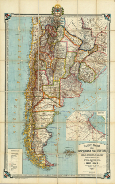
English: New map of the Republic of Argentina, Chile, Uruguay and Paraguay made and published by the Cartographic Office of Pablo Ludwig according to the most recent data. Buenos Aires, 1914, Gunche, Wiebeck and Turtl- O'Brien 121, Bs. As. (with Greater Buenos Aires inset) Español: Nuevo mapa de la Republica Argentina, Chile, Uruguay y Paraguay construido y publicado por la Oficina Cartografica de Pablo Ludwig segun los datos mas recientes. Buenos Aires,1914. Gunche, Wiebeck y Turtl-O'Brien 121, Bs. As. (con Alrededores de Buenos Aires) |
||||
| Date | (UTC) | ||||
| Source | |||||
| Author |
|
||||
| Permission (Reusing this file) |
|
||||
| Other versions | |||||
.jpg)
Original upload log[edit]
.png&action=edit§ion=2)
This image is a derivative work of the following images:
- File:Nuevo_mapa_de_la_Republica_Argentina_(1914).djvu licensed with PD-old
- 2008-09-15T23:15:14Z Createaccount 4719x7535 (8985530 Bytes) {{Information |Description={{es|1=Nuevo mapa de la Republica Argentina, Chile, Uruguay y Paraguay construido y publicado por la Oficina Cartografica de Pablo Ludwig segun los datos mas recientes. Buenos Aires,1914. Gunche, Wi
File history
Click on a date/time to view the file as it appeared at that time.
| Date/Time | Thumbnail | Dimensions | User | Comment | |
|---|---|---|---|---|---|
| current | 13:20, 12 September 2010 | | 4,719 × 7,535 (51.97 MB) | Malus Catulus (talk | contribs) | {{Information |Description={{en|1=yesh}} |Source=yesh |Author=yesh |Date= |Permission=yesh |other_versions= }} |
You cannot overwrite this file.
File usage on Commons
The following page uses this file:
.png&oldid=737063427)