File:Nuclear use locations world map.PNG
Jump to navigation
Jump to search

Size of this preview: 800 × 367 pixels. Other resolutions: 320 × 147 pixels | 640 × 293 pixels | 1,357 × 622 pixels.
Original file (1,357 × 622 pixels, file size: 47 KB, MIME type: image/png)
Captions
Captions
Add a one-line explanation of what this file represents
Summary[edit]
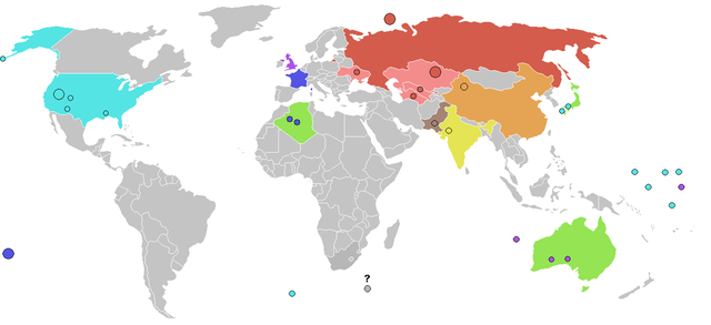
English: Map of locations of Nuclear tests and use of nuclear weapons in the twentieth century. The only use of nuclear weapons in war is at Nagasaki and Hiroshima in Japan. Locations of nuclear tests or weapons as dots. Major test sites with more than 100 tests marked as large dots (Nevada USA, Mururoa atoll in the Pacific, Semipalatinsk in Kazakhstan and Novaya Zemlya island north of Russia). Not sure of the exact location of nuclear testing within Ukraine, Uzbekistan or Turkmenistan - the dot in these cases denotes that there was testing in those countries, rather than a specific location in these countries. The site in North Korea is not indicated..
Polski: Na mapie zaznaczone są miejsca próbnych wybuchów jądrowych. Jedynym przypadkiem użycia militarnego broni jądrowej było zrzucenie bomb jądrowych na Hiroszimę i Nagasaki w Japonii. Miejsca wybuchów są zaznaczone kropkami. Tam gdzie zostało wykonane ponad 100 testów zaznaczone jest dużymi kropkami (Nevada, atol Mururoa na Pacyfiku i Wyspy Nowa Ziemia na północy Rosji). Nie ma pewności co do prób jądrowych na Ukrainie, w Uzbekistanie i Turkmenistanie - kropki zaznaczone na terenie tych państw nie są konkretnymi miejscami detonacji.
Русский: Карта мест ядерных испытаний и применения ядерного оружия.Ядерное оружие применено в войне только в Нагасаки и Хиросиме в Японии.Места ядерных испытаний указаны точками.Полигоны, на которых проводилось более 100 испытаний отмечены большими точками (Невада в США, атол Муруора в Тихом океане, Семипалатинск в Казахстане и остров Новая Земле на севере России).Не известны точно места ядерных испытаний в Украине, Узбекистане и Туркменистане - точки в этом случае означают, что испытание проводилось в этих странах, а не в конкретном месте страны.
USSR (light red for former Soviet republics outside Russia where nuclear weapons were tested, dark red for Russia which is the only former Soviet republic which still has nuclear weapons / jasnym czerwonym są zaznaczone republiki radzieckie gdzie były wykonywane testy / светло-красный для бывших советских республик кроме России)
USA
France
UK
China
India
Pakistan
North Korea
areas where nuclear devices belonging to another country have been used. / Miejsca gdzie obce kraje używały urządzeń nuklearnych / страны, на территории которых использовался ядерный заряд принадлежащий другой стране
question mark denotes the possible Vela incident / znak zapytania oznacza miejsce, do którego nie ma pewności co do testów jądrowych / вопрос означает возможнй инцидент Вела
See also these maps at external sites: / Zobacz również: / Смотри также эту карту на других сайтах: [1], [2], [3], [4]
![[1]](http://www.cbsnews.com/htdocs/nuclear_weapons/images/map_nuclear_tests2.gif)
![[2]](http://www.cddc.vt.edu/host/atomic/images/tstmap1a.gif)
Licensing[edit]

|
Permission is granted to copy, distribute and/or modify this document under the terms of the GNU Free Documentation License, Version 1.2 or any later version published by the Free Software Foundation; with no Invariant Sections, no Front-Cover Texts, and no Back-Cover Texts. A copy of the license is included in the section entitled GNU Free Documentation License. |
| This file is licensed under the Creative Commons Attribution-Share Alike 3.0 Unported license. | ||
| ||
| This licensing tag was added to this file as part of the GFDL licensing update. |
File history
Click on a date/time to view the file as it appeared at that time.
| Date/Time | Thumbnail | Dimensions | User | Comment | |
|---|---|---|---|---|---|
| current | 13:12, 21 March 2006 | | 1,357 × 622 (47 KB) | Roke~commonswiki (talk | contribs) | add vela incident, minor changes |
| 05:16, 21 March 2006 |  | 1,357 × 622 (47 KB) | Roke~commonswiki (talk | contribs) | shite forgot to crop | |
| 05:14, 21 March 2006 |  | 1,357 × 1,184 (66 KB) | Roke~commonswiki (talk | contribs) | different colour for countries | |
| 09:39, 14 February 2006 |  | 1,357 × 628 (30 KB) | Roke~commonswiki (talk | contribs) | remove microstates which add confusion | |
| 09:28, 14 February 2006 |  | 1,357 × 628 (31 KB) | Roke~commonswiki (talk | contribs) | Map of locations of Nuclear tests and use of nuclear weapons. Countries where nuclear weapons used marked in green. Locations of nuclear tests or weapons as red dots. Major test sites with more than 100 tests marked as large red dots (Nevada USA, Mururoa |
You cannot overwrite this file.
File usage on Commons
There are no pages that use this file.
File usage on other wikis
The following other wikis use this file:
- Usage on fr.wikipedia.org
- Usage on hi.wikipedia.org
- Usage on ja.wikipedia.org
- Usage on kk.wikipedia.org
- Usage on nl.wikipedia.org
- Usage on pt.wikipedia.org
- Usage on ro.wikipedia.org
- Usage on ru.wikipedia.org
- Usage on ta.wikipedia.org
- Usage on te.wikipedia.org
- Usage on uk.wikipedia.org
- Usage on wuu.wikipedia.org
- Usage on zh.wikipedia.org