File:Nsdap gaue.png

Original file (8,881 × 5,622 pixels, file size: 1.87 MB, MIME type: image/png)
Captions
Captions

|
This locator map image could be re-created using vector graphics as an SVG file. This has several advantages; see Commons:Media for cleanup for more information. If an SVG form of this image is available, please upload it and afterwards replace this template with
{{vector version available|new image name}}.
It is recommended to name the SVG file “Nsdap gaue.svg”—then the template Vector version available (or Vva) does not need the new image name parameter. |
Summary[edit]
| Description |
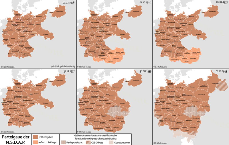
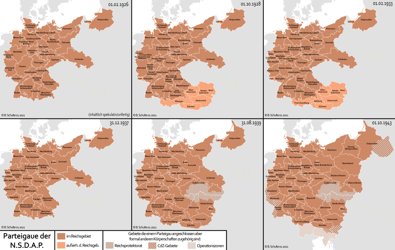
Deutsch: Karten der parteilichen administrativen Gliederung der NSDAP in Parteigaue (auch außerhalb des Deutschen Reiches). Diese ist nicht identisch mit der staatlichen Gliederung bspw. der Reichsgaue.
English: Maps of the party administrative organization of the NSDAP in Parteigaue (also outside of the German Empire). This is not identical with the state structure for example of Reichsgaue.
Polski: Mapa partyjnej organizacji administracyjnej NSDAP w Parteigaue (też poza Rzeszą Niemiecką). Nie jest identyczny z opisanym w Przykładzie zarys stanu Reichsgaue. |
||
| Date | |||
| Source | Own work | ||
| Author | Bennet Schulte | ||
| Permission (Reusing this file) |
This file is licensed under the Creative Commons Attribution-Share Alike 3.0 Germany license.
 |
||
| Other versions |
|


Licensing[edit]
- You are free:
- to share – to copy, distribute and transmit the work
- to remix – to adapt the work
- Under the following conditions:
- attribution – You must give appropriate credit, provide a link to the license, and indicate if changes were made. You may do so in any reasonable manner, but not in any way that suggests the licensor endorses you or your use.
- share alike – If you remix, transform, or build upon the material, you must distribute your contributions under the same or compatible license as the original.

|
Permission is granted to copy, distribute and/or modify this document under the terms of the GNU Free Documentation License, Version 1.2 or any later version published by the Free Software Foundation; with no Invariant Sections, no Front-Cover Texts, and no Back-Cover Texts. A copy of the license is included in the section entitled GNU Free Documentation License. |
File history
Click on a date/time to view the file as it appeared at that time.
| Date/Time | Thumbnail | Dimensions | User | Comment | |
|---|---|---|---|---|---|
| current | 22:07, 16 January 2021 | | 8,881 × 5,622 (1.87 MB) | Exec (talk | contribs) | - unfangreiche Überarbeitungen und Erweiterungen anhand aktuellen Forschungsstandes |
| 01:25, 6 December 2013 |  | 8,881 × 5,315 (676 KB) | Exec (talk | contribs) | -1939 und 1943 hinzugefügt -Farbschema angepasst | |
| 21:37, 11 April 2013 |  | 2,362 × 2,000 (211 KB) | Exec (talk | contribs) | Gau Rheinland-Nord für 1.10.1928 geändert in Gau Rheinland | |
| 21:32, 11 April 2013 |  | 2,362 × 2,000 (211 KB) | Exec (talk | contribs) | Gau Westfalen für 1.10.1928 geändert in Gau Ruhr | |
| 20:42, 11 April 2013 |  | 2,362 × 2,000 (211 KB) | Exec (talk | contribs) | 1926 and 1928 switched | |
| 20:34, 11 April 2013 |  | 2,362 × 2,000 (211 KB) | Exec (talk | contribs) | -multiple content issues fixed (Saar, Hessen-Darmstadt ...) -increased resultion | |
| 07:15, 20 January 2011 |  | 1,549 × 1,299 (65 KB) | Exec (talk | contribs) | - Gau Ost-Hannover was Gau Lüneburg-Stade until September 30 1928 - croping and squeezing suggestion realized with title and credits | |
| 19:49, 31 August 2010 |  | 1,549 × 1,299 (44 KB) | Ras67 (talk | contribs) | cropped and squeezed | |
| 07:44, 30 August 2010 |  | 1,576 × 1,382 (57 KB) | Exec (talk | contribs) | Rheinpfalz Problem gelöst | |
| 17:02, 27 August 2010 |  | 1,576 × 1,382 (57 KB) | Exec (talk | contribs) | westfalen entfernt |
You cannot overwrite this file.
File usage on Commons
The following 3 pages use this file:
File usage on other wikis
The following other wikis use this file:
- Usage on af.wikipedia.org
- Usage on azb.wikipedia.org
- Usage on br.wikipedia.org
- Usage on bs.wikipedia.org
- Usage on ca.wikipedia.org
- Usage on cy.wikipedia.org
- Usage on da.wikipedia.org
- Usage on de.wikipedia.org
- Usage on eo.wikipedia.org
- Usage on et.wikipedia.org
- Usage on fr.wikipedia.org
- Usage on fy.wikipedia.org
- Usage on gl.wikipedia.org
- Usage on hr.wikipedia.org
- Usage on it.wikipedia.org
- Usage on ja.wikipedia.org
- Usage on ka.wikipedia.org
- Usage on la.wikipedia.org
- Usage on lt.wikipedia.org
- Usage on mk.wikipedia.org
- Usage on ml.wikipedia.org
- Usage on nds.wikipedia.org
- Usage on nl.wikipedia.org
- Usage on pl.wikipedia.org
- Usage on pnb.wikipedia.org
View more global usage of this file.