File:Northern Mariana Islands map.gif
Jump to navigation
Jump to search
No higher resolution available.
Northern_Mariana_Islands_map.gif (345 × 371 pixels, file size: 24 KB, MIME type: image/gif)
Captions
Captions
Add a one-line explanation of what this file represents
Summary[edit]
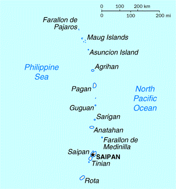
| Description | Map of the Northern Mariana Islands |
| Source | http://www.doi.gov/oia/Islandpages/cnmipage.htm |
| Author | United States Department of the Interior |
Licensing[edit]
| This image or media file contains material based on a work of a United States Department of the Interior employee, created as part of that person's official duties. As a work of the U.S. federal government, such work is in the public domain in the United States. See the Department of the Interior copyright policy for more information. |  |
File history
Click on a date/time to view the file as it appeared at that time.
| Date/Time | Thumbnail | Dimensions | User | Comment | |
|---|---|---|---|---|---|
| current | 03:17, 18 August 2010 | | 345 × 371 (24 KB) | Ras67 (talk | contribs) | cropped |
| 00:24, 17 May 2008 |  | 351 × 377 (25 KB) | Scanlan (talk | contribs) | {{Information |Description=Map of the Northern Mariana Islands |Source=http://www.doi.gov/oia/Islandpages/cnmipage.htm |Date= |Author=United States Department of the Interior |Permission= |other_versions= }} [[Category:Maps of the Northern Marian |
You cannot overwrite this file.
File usage on Commons
There are no pages that use this file.
File usage on other wikis
The following other wikis use this file:
- Usage on af.wikipedia.org
- Usage on ar.wikipedia.org
- Usage on ast.wikipedia.org
- Usage on be-tarask.wikipedia.org
- Usage on bn.wikipedia.org
- Usage on ch.wikipedia.org
- Usage on cs.wikipedia.org
- Usage on cy.wikipedia.org
- Usage on da.wikipedia.org
- Usage on en.wikipedia.org
- Usage on es.wikipedia.org
- Usage on fa.wikipedia.org
- Usage on fr.wikipedia.org
- Usage on he.wikipedia.org
- Usage on id.wikipedia.org
- Usage on incubator.wikimedia.org
- Usage on io.wikipedia.org
- Usage on ja.wikipedia.org
- Usage on ka.wikipedia.org
- Usage on ml.wikipedia.org
- Usage on mr.wikipedia.org
- Usage on pt.wikipedia.org
- Usage on ru.wikipedia.org
- Usage on ta.wikipedia.org
- Usage on to.wikipedia.org
- Usage on tr.wiktionary.org
- Usage on tt.wikipedia.org
- Usage on uk.wikipedia.org