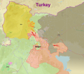
File:Northern Aleppo offensive (2016).svg
From Wikimedia Commons, the free media repository
Jump to navigation
Jump to search

Size of this PNG preview of this SVG file: 689 × 599 pixels. Other resolutions: 276 × 240 pixels | 552 × 480 pixels | 883 × 768 pixels | 1,177 × 1,024 pixels | 2,354 × 2,048 pixels | 2,644 × 2,300 pixels.
Original file (SVG file, nominally 2,644 × 2,300 pixels, file size: 9.43 MB)
File information
Structured data
Captions
Captions
Add a one-line explanation of what this file represents
Summary[edit]
| DescriptionNorthern Aleppo offensive (2016).svg |
English: Map showing the course of the 2016 Northern Aleppo offensive. Dotted red line show government frontline before offensive, dotted orange line shows YPG frontline before offensive (Offensive began 1 February 2016).
|
| Date | |
| Source | Own work |
| Author | MrPenguin20 |
Licensing[edit]
I, the copyright holder of this work, hereby publish it under the following license:
This file is licensed under the Creative Commons Attribution-Share Alike 4.0 International license.
- You are free:
- to share – to copy, distribute and transmit the work
- to remix – to adapt the work
- Under the following conditions:
- attribution – You must give appropriate credit, provide a link to the license, and indicate if changes were made. You may do so in any reasonable manner, but not in any way that suggests the licensor endorses you or your use.
- share alike – If you remix, transform, or build upon the material, you must distribute your contributions under the same or compatible license as the original.
File history
Click on a date/time to view the file as it appeared at that time.
| Date/Time | Thumbnail | Dimensions | User | Comment | |
|---|---|---|---|---|---|
| current | 22:55, 22 February 2016 |  | 2,644 × 2,300 (9.43 MB) | MrPenguin20 (talk | contribs) | Update. |
| 01:49, 21 February 2016 |  | 2,644 × 2,300 (9.37 MB) | MrPenguin20 (talk | contribs) | Government advances in East Aleppo. | |
| 11:51, 17 February 2016 |  | 2,644 × 2,300 (9.38 MB) | MrPenguin20 (talk | contribs) | Updates. | |
| 21:13, 15 February 2016 |  | 2,644 × 2,300 (9.37 MB) | MrPenguin20 (talk | contribs) | Updates. | |
| 17:16, 15 February 2016 |  | 2,644 × 2,300 (9.38 MB) | MrPenguin20 (talk | contribs) | Tel Rifaat taken by YPG. | |
| 16:58, 15 February 2016 |  | 2,644 × 2,300 (9.38 MB) | MrPenguin20 (talk | contribs) | YPG pushing on Ehras. | |
| 16:53, 15 February 2016 |  | 2,644 × 2,300 (9.37 MB) | MrPenguin20 (talk | contribs) | Misqan taken by government forces. Fighting in Tel Rifaat again (reports say mostly now under YPG control, although will change when confirmed). | |
| 12:54, 15 February 2016 |  | 2,644 × 2,300 (9.37 MB) | MrPenguin20 (talk | contribs) | Updates. Pro-government forces withdraw from Kafr Naya - now in Kurdish control. Tell Rifaat fighting over (for now). Kurds take Kafr Kashir. | |
| 00:30, 15 February 2016 |  | 2,644 × 2,300 (9.37 MB) | MrPenguin20 (talk | contribs) | Update. | |
| 15:47, 12 February 2016 |  | 2,644 × 2,300 (9.37 MB) | MrPenguin20 (talk | contribs) | Tweaks around Azaz. |
You cannot overwrite this file.
File usage on Commons
The following 15 pages use this file:
- File:Aleppo offensive (October 2013).svg
- File:Rif Aleppo2.svg
- Template:Maps of the civil war in Aleppo
- Category:Aleppo
- Category:Battle of Aleppo
- Category:Battles in 2016
- Category:Battles in 2022
- Category:Battles in 2023
- Category:Battles in 2024
- Category:Battles of Syria
- Category:Battles of the Syrian Civil War
- Category:Cities in Syria
- Category:Maps of Aleppo
- Category:Ongoing armed conflicts
- Category:Syrian Civil War
File usage on other wikis
The following other wikis use this file:
- Usage on ar.wikipedia.org
- Usage on ca.wikipedia.org
- Usage on cs.wikipedia.org
- Usage on en.wikipedia.org
- Usage on es.wikipedia.org
- Usage on fr.wikipedia.org
- Usage on hu.wikipedia.org
- Usage on it.wikipedia.org
- Usage on ko.wikipedia.org
- Usage on pl.wikipedia.org
- Usage on pt.wikipedia.org
- Usage on tr.wikipedia.org
- Usage on www.wikidata.org
Metadata
This file contains additional information such as Exif metadata which may have been added by the digital camera, scanner, or software program used to create or digitize it. If the file has been modified from its original state, some details such as the timestamp may not fully reflect those of the original file. The timestamp is only as accurate as the clock in the camera, and it may be completely wrong.
| Width | 2115pt |
|---|---|
| Height | 1840pt |