File:NorthernWallkillValley.png
Jump to navigation
Jump to search

Size of this preview: 366 × 599 pixels. Other resolutions: 147 × 240 pixels | 293 × 480 pixels | 1,011 × 1,654 pixels.
Original file (1,011 × 1,654 pixels, file size: 2.82 MB, MIME type: image/png)
Captions
Captions
Add a one-line explanation of what this file represents
Summary[edit]
| Description |
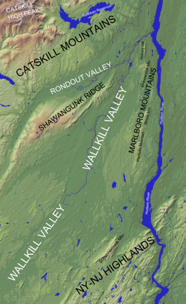
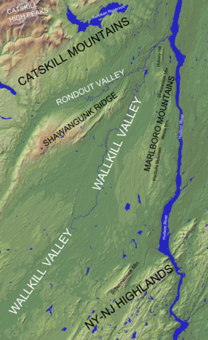
English: Section of a north-up oriented shaded relief map of the U.S. state of New York (from the United States Geological Survey) showing the extent of the northern Wallkill Valley. Geographic features have been labeled |
| Date | |
| Source | |
| Author |
|
| This is a retouched picture, which means that it has been digitally altered from its original version. Modifications: Cropped from original USGS work, lightened, and added labels. The original can be viewed here: New York Relief 1.jpg:
|
This image is in the public domain in the United States because it only contains materials that originally came from the United States Geological Survey, an agency of the United States Department of the Interior. For more information, see the official USGS copyright policy.
|
File history
Click on a date/time to view the file as it appeared at that time.
| Date/Time | Thumbnail | Dimensions | User | Comment | |
|---|---|---|---|---|---|
| current | 04:24, 18 October 2014 | | 1,011 × 1,654 (2.82 MB) | Lithium6ion (talk | contribs) | {{Information |Description ={{en|1=Section of a north-up oriented shaded relief map of the U.S. state of New York (from the United States Geological Survey) showing the extent of the Wallkill Valley. Geographic features have... |
You cannot overwrite this file.
File usage on Commons
There are no pages that use this file.
File usage on other wikis
The following other wikis use this file:
- Usage on en.wikipedia.org
- Usage on zh.wikipedia.org