File:North atlantic deep water-de.svg
Jump to navigation
Jump to search

Size of this PNG preview of this SVG file: 800 × 471 pixels. Other resolutions: 320 × 189 pixels | 640 × 377 pixels | 1,024 × 603 pixels | 1,280 × 754 pixels | 2,560 × 1,509 pixels | 4,032 × 2,376 pixels.
Original file (SVG file, nominally 4,032 × 2,376 pixels, file size: 126 KB)
Captions
Captions
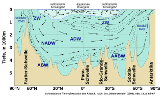
Schematic representation of the deep circulation of the Atlantic ocean
Summary[edit]
| Description |
Deutsch: Schematisches Darstellung der Tiefenzirkulation des Atlantik, nach Jörg Ott „Meereskunde“ Abb. 19. Die Abkürzung TW für das Atlantische Tiefenwasser wurde in ADW (Atlantic Deep Water) geändert und das Kürzel NADW (North Atlantic Deep Water) als wichtiger Teil des ADW gemäß der Beschreibung auf S. 65–66 ergänzt. Weiter Abkürzungen nach Ott (ABW: Arctic Bottom Water, AABW: Antarctic Bottom Water, ZW: Atlantisches Zwischenwasser), Warmwassersphäre hellblau, Kaltwassersphäre dunkelblau
English: Schematic representation of the deep circulation of the Atlantic ocean, drawn after Jörg Ott „Meereskunde“ fig. 19. |
| Date | |
| Source | Own work |
| Author | DeWikiMan |
Licensing[edit]
I, the copyright holder of this work, hereby publish it under the following licenses:

|
Permission is granted to copy, distribute and/or modify this document under the terms of the GNU Free Documentation License, Version 1.2 or any later version published by the Free Software Foundation; with no Invariant Sections, no Front-Cover Texts, and no Back-Cover Texts. A copy of the license is included in the section entitled GNU Free Documentation License. |
If this file is eligible for relicensing, it may also be used under the Creative Commons Attribution-ShareAlike 3.0 license. The relicensing status of this image has not yet been reviewed. You can help.
|
This file is licensed under the Creative Commons Attribution license, versions 1.0, 2.0, 2.5, 3.0, 4.0 and any later version released by Creative Commons. You may select the version of your choice. In short: you are free to share and make derivative works of the file under the conditions that you appropriately attribute it. Official license: 1.0, 2.0, 2.5, 3.0, 4.0
|
If this file was uploaded before Jan. 10th, 2013 it is licensed under:
This file is licensed under the Creative Commons Attribution 3.0 Unported, 2.5 Generic, 2.0 Generic and 1.0 Generic license.
- You are free:
- to share – to copy, distribute and transmit the work
- to remix – to adapt the work
- Under the following conditions:
- attribution – You must give appropriate credit, provide a link to the license, and indicate if changes were made. You may do so in any reasonable manner, but not in any way that suggests the licensor endorses you or your use.
You may select the license of your choice.
File history
Click on a date/time to view the file as it appeared at that time.
| Date/Time | Thumbnail | Dimensions | User | Comment | |
|---|---|---|---|---|---|
| current | 20:35, 19 February 2022 | | 4,032 × 2,376 (126 KB) | DeWikiMan (talk | contribs) | == {{int:filedesc}} == {{Information |Description= {{de|Schematisches Darstellung der Tiefenzirkulation des Atlantik, nach Jörg Ott „Meereskunde“ Abb. 19. Die Abkürzung TW für das Atlantische Tiefenwasser wurde in ADW (Atlantic Deep Water) geändert und das Kürzel NADW (North Atlantic Deep Water) als wichtiger Teil des ADW gemäß der Beschreibung auf S. 65–66 ergänzt. Weiter Abkürzungen nach Ott (ABW: Arctic Bottom Water, AABW: Antarctic Bottom Water, ZW: Atlantisches Zwischenwasser), Warmwasse... |
You cannot overwrite this file.
File usage on Commons
The following page uses this file:
File usage on other wikis
The following other wikis use this file:
- Usage on de.wikipedia.org