File:North Sea Mine Barrage map 1918.png
Jump to navigation
Jump to search

Size of this preview: 490 × 599 pixels. Other resolutions: 196 × 240 pixels | 392 × 480 pixels | 902 × 1,103 pixels.
Original file (902 × 1,103 pixels, file size: 234 KB, MIME type: image/png)
Captions
Captions
Add a one-line explanation of what this file represents
Summary
[edit]
| Description |
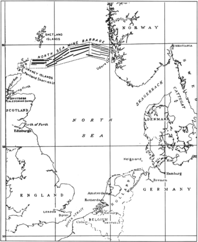
English: Map of the North Sea Mine Barrage, laid in the Summer of 1918. The mine barrage consisted of 18 rows of mines laid in an east-west direction between the Orkneys and Norway. The minefield was laid by British and U.S. ships. 56,571 of the 70,177 mines were deployed by the U.S. Navy. |
| Date | |
| Source | U.S. Navy All Hands magazine April 1986, p. 20. |
| Author | U.S. Navy |
Licensing
[edit]
This file is a work of a sailor or employee of the U.S. Navy, taken or made as part of that person's official duties. As a work of the U.S. federal government, it is in the public domain in the United States.
|
 | |
| This file has been identified as being free of known restrictions under copyright law, including all related and neighboring rights. | ||
File history
Click on a date/time to view the file as it appeared at that time.
| Date/Time | Thumbnail | Dimensions | User | Comment | |
|---|---|---|---|---|---|
| current | 17:45, 3 January 2015 | | 902 × 1,103 (234 KB) | Cobatfor (talk | contribs) | == {{int:filedesc}} == {{Information |Description={{en|1=Map of the North Sea Mine Barrage, laid in the Summer of 1918. The mine barrage consisted of 18 rows of mines laid in an east-west direction between the Orkneys and Norway. The minefield was laid... |
You cannot overwrite this file.
File usage on Commons
The following page uses this file:
File usage on other wikis
The following other wikis use this file:
- Usage on ar.wikipedia.org
- Usage on ca.wikipedia.org
- Usage on de.wikipedia.org
- Usage on en.wikipedia.org
- Usage on fr.wikipedia.org
- Usage on hu.wikipedia.org
- Usage on pl.wikipedia.org
- Usage on ru.wikipedia.org
- Usage on uk.wikipedia.org
- Usage on www.wikidata.org