File:North America.png
Jump to navigation
Jump to search
Size of this preview: 466 × 599 pixels. Other resolutions: 187 × 240 pixels | 373 × 480 pixels | 673 × 865 pixels.
Original file (673 × 865 pixels, file size: 709 KB, MIME type: image/png)
Captions
Captions
Add a one-line explanation of what this file represents
Summary[edit]
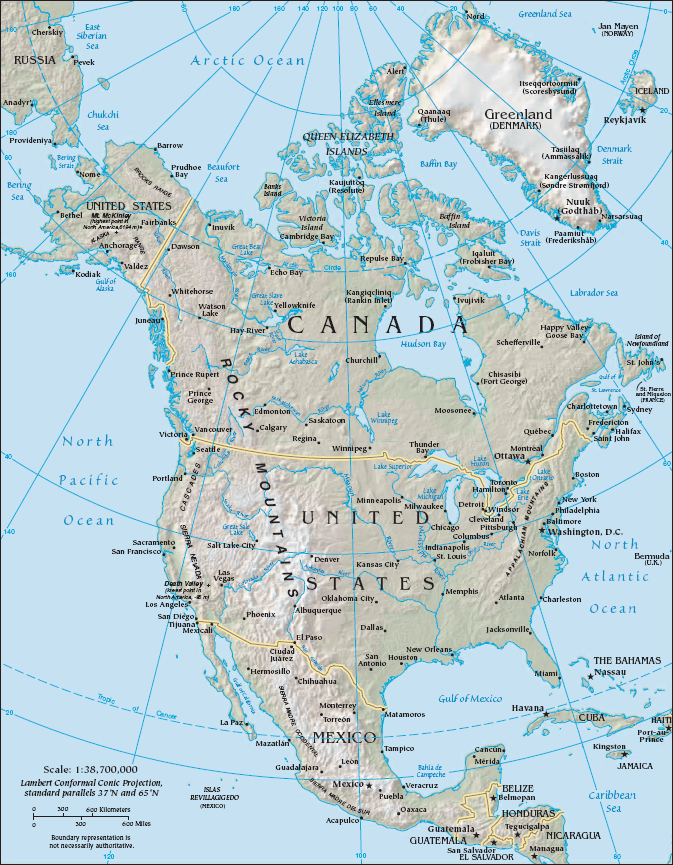
| Description | Physical and Political map of North America |
| Source | The CIA FactBook at https://www.cia.gov/library/publications/resources/the-world-factbook/docs/refmaps.html |
| Author | US Federal Government |
| Permission (Reusing this file) |
Public Domain |
| Other versions |
[]
|


Licensing[edit]
This image is in the public domain because it contains materials that originally came from the United States Central Intelligence Agency's World Factbook.
|
 |
File history
Click on a date/time to view the file as it appeared at that time.
| Date/Time | Thumbnail | Dimensions | User | Comment | |
|---|---|---|---|---|---|
| current | 06:19, 25 June 2011 | | 673 × 865 (709 KB) | AlexCovarrubias (talk | contribs) | Cropping map to avoid title bar |
| 06:22, 16 September 2006 |  | 675 × 894 (686 KB) | Shushruth (talk | contribs) | {{Information |Description=Physical and Political map of North America |Source=The CIA FactBook at https://www.cia.gov/cia/publications/factbook/reference_maps/north_america.html |Author= US Federal Government |Permission= Public Domain }} |
You cannot overwrite this file.
File usage on Commons
The following 9 pages use this file:
File usage on other wikis
The following other wikis use this file:
- Usage on af.wikipedia.org
- Usage on ca.wikipedia.org
- Usage on cy.wikipedia.org
- Usage on de.wikipedia.org
- Usage on en.wikipedia.org
- History of North America
- North American Cordillera
- User:Jre
- User:Louis Waweru
- User:Jcmenal
- User:Billgdiaz
- User:Jcmenal/North American
- User:Seanwarner86
- User:Vreddy92
- User:Tang Wenlong
- User:Backvoods
- User:Djdavi
- User:Kev098
- User:Mokoniki
- User:Rocco avila
- User:Stiddy
- User:Yongbyong38
- User:Trfaes/North American
- User:Trfaes
- User:Brout8
- Usage on eo.wikipedia.org
- Usage on es.wikipedia.org
- Usage on es.wikibooks.org
- Usage on eu.wikipedia.org
- Usage on fa.wikipedia.org
- Usage on fi.wikipedia.org
- Usage on id.wikipedia.org
- Usage on ilo.wikipedia.org
- Usage on incubator.wikimedia.org
View more global usage of this file.