File:North-western coast of St Mary's, Scilly - geograph.org.uk - 1607998.jpg
Jump to navigation
Jump to search
No higher resolution available.
North-western_coast_of_St_Mary's,_Scilly_-_geograph.org.uk_-_1607998.jpg (640 × 417 pixels, file size: 82 KB, MIME type: image/jpeg)
Captions
Captions
Add a one-line explanation of what this file represents
Summary[edit]
| Description |
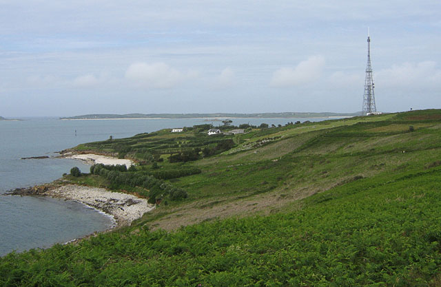
English: North-western coast of St Mary's, Scilly This was taken from near Carn Morval, a rock outcrop on the west coast of St Mary's. The two bays visible here are Toll's Porth (below left) and Halangy Porth (centre-left). Toll's Porth is uniformly stony, whereas Halangy Porth has a sandy upper beach. At the right, the land rises to over 45 metres at the Telegraph, with the radio mast. On the slope between Halangy Porth and the Telegraph is the Halangy Down ancient village. |
| Date | |
| Source | From geograph.org.uk |
| Author | John Rostron |
| Attribution (required by the license) | John Rostron / North-western coast of St Mary's, Scilly / |
| Camera location | | View this and other nearby images on: OpenStreetMap |
|---|
_heading:22.00&language=en)
| Object location | | View this and other nearby images on: OpenStreetMap |
|---|
_heading:22.00&language=en)
Licensing[edit]

|
This image was taken from the Geograph project collection. See this photograph's page on the Geograph website for the photographer's contact details. The copyright on this image is owned by John Rostron and is licensed for reuse under the Creative Commons Attribution-ShareAlike 2.0 license.
|
This file is licensed under the Creative Commons Attribution-Share Alike 2.0 Generic license.
Attribution: John Rostron
- You are free:
- to share – to copy, distribute and transmit the work
- to remix – to adapt the work
- Under the following conditions:
- attribution – You must give appropriate credit, provide a link to the license, and indicate if changes were made. You may do so in any reasonable manner, but not in any way that suggests the licensor endorses you or your use.
- share alike – If you remix, transform, or build upon the material, you must distribute your contributions under the same or compatible license as the original.
File history
Click on a date/time to view the file as it appeared at that time.
| Date/Time | Thumbnail | Dimensions | User | Comment | |
|---|---|---|---|---|---|
| current | 06:58, 4 March 2011 | | 640 × 417 (82 KB) | GeographBot (talk | contribs) | == {{int:filedesc}} == {{Information |description={{en|1=North-western coast of St Mary's, Scilly This was taken from near Carn Morval, a rock outcrop on the west coast of St Mary's. The two bays visible here are Toll's Porth (below left) and Halangy Port |
You cannot overwrite this file.
File usage on Commons
There are no pages that use this file.