File:Nord-Ostsee-Bahn Streckenplan Bredstedt.jpg
Jump to navigation
Jump to search

Size of this preview: 328 × 599 pixels. Other resolutions: 131 × 240 pixels | 262 × 480 pixels | 420 × 768 pixels | 560 × 1,024 pixels | 1,976 × 3,611 pixels.
Original file (1,976 × 3,611 pixels, file size: 3.38 MB, MIME type: image/jpeg)
Captions
Captions
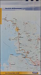
A Routeplan from the Nord-Ostsee-Bahn from ca. 2009
Summary[edit]
| Description |
English: This photo shows the entire route plan the Nord-Ostsee-Bahn (NOB) Had in the year 2010
Deutsch: Dieses Foto zeigt alle Routen der Nord-Ostsee-Bahn aus dem Jahr 2010 |
| Date | |
| Source | Own work |
| Author | Niklas428 |
| Camera location | | View this and other nearby images on: OpenStreetMap |
|---|
Licensing[edit]
I, the copyright holder of this work, hereby publish it under the following license:
This file is licensed under the Creative Commons Attribution-Share Alike 4.0 International license.
- You are free:
- to share – to copy, distribute and transmit the work
- to remix – to adapt the work
- Under the following conditions:
- attribution – You must give appropriate credit, provide a link to the license, and indicate if changes were made. You may do so in any reasonable manner, but not in any way that suggests the licensor endorses you or your use.
- share alike – If you remix, transform, or build upon the material, you must distribute your contributions under the same or compatible license as the original.
File history
Click on a date/time to view the file as it appeared at that time.
| Date/Time | Thumbnail | Dimensions | User | Comment | |
|---|---|---|---|---|---|
| current | 06:22, 18 September 2022 | | 1,976 × 3,611 (3.38 MB) | Niklas428 (talk | contribs) | Uploaded own work with UploadWizard |
You cannot overwrite this file.
File usage on Commons
The following page uses this file: