File:Nominy Church, Virginia Historical Marker No. JT-2; British Landing at Nomini Ferry, Virginia Historical Marker No. JT-92, Nomini, Virginia (14486117485).jpg

Original file (1,004 × 760 pixels, file size: 150 KB, MIME type: image/jpeg)
Captions
Captions
Summary[edit]
.jpg&action=edit§ion=1)
| Description |
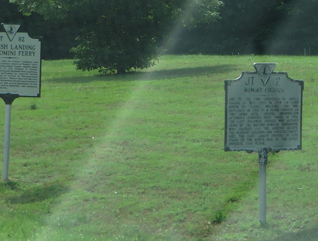
British Landing at Nomini Ferry: On 20 July 1814, Adm. Sire George Cockburn sent about a thousand marines ashore at Nomini Ferry to attack the Westmoreland County militia under the command of Lt. Col. Richard E. Parker. Parker's Virginians bravely defended their positions, but were soon forced to retreat to Westmoreland Court House (Montross). Before they left the next morning, the British marines burned and destroyed a number of houses and several plantations in the immediate area, such as Bushfield, and ransacked nearby Nomini Church. Nominy Church: One of the two churchs in Cople Parish. It was built in 1704 on land given by Youell Watkins, and was replaced in 1755 by a brick church on the same site. George Washington attended services here twice in 1768. The last colonial church was burned (1814) by the British Admiral Cockburn, who carried off the church silver. The present building was erected about 1852. The first Nomimy Church of 1655 stood on the north side of the river opposite this place. |
| Date | |
| Source | Nominy Church, Virginia Historical Marker No. JT-2; British Landing at Nomini Ferry, Virginia Historical Marker No. JT-92, Nomini, Virginia |
| Author | Ken Lund from Reno, Nevada, USA |
| Camera location | | View this and other nearby images on: OpenStreetMap |
|---|
.jpg¶ms=038.098313_N_-076.729523_E_globe:Earth_type:camera_source:Flickr_&language=en)
Licensing[edit]
.jpg&action=edit§ion=2)
- You are free:
- to share – to copy, distribute and transmit the work
- to remix – to adapt the work
- Under the following conditions:
- attribution – You must give appropriate credit, provide a link to the license, and indicate if changes were made. You may do so in any reasonable manner, but not in any way that suggests the licensor endorses you or your use.
- share alike – If you remix, transform, or build upon the material, you must distribute your contributions under the same or compatible license as the original.
| This image was originally posted to Flickr by Ken Lund at https://flickr.com/photos/75683070@N00/14486117485. It was reviewed on 6 April 2016 by FlickreviewR and was confirmed to be licensed under the terms of the cc-by-sa-2.0. |
File history
Click on a date/time to view the file as it appeared at that time.
| Date/Time | Thumbnail | Dimensions | User | Comment | |
|---|---|---|---|---|---|
| current | 17:32, 6 April 2016 | | 1,004 × 760 (150 KB) | Ser Amantio di Nicolao (talk | contribs) | Transferred from Flickr via Flickr2Commons |
You cannot overwrite this file.
File usage on Commons
There are no pages that use this file.
.jpg&oldid=575748389)