File:Niger-Congo map with delimitation.png
Jump to navigation
Jump to search
Size of this preview: 635 × 599 pixels. Other resolutions: 254 × 240 pixels | 509 × 480 pixels | 814 × 768 pixels | 1,207 × 1,139 pixels.
Original file (1,207 × 1,139 pixels, file size: 347 KB, MIME type: image/png)
Captions
Captions
Add a one-line explanation of what this file represents
| Description |
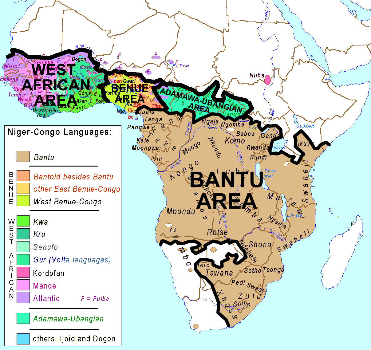
vectorisation de Image:Niger-Congo.png Vectorization of Image:Niger-Congo.png, which is CC-by: Map showing the localization of Niger Congo subgroups and important single languages of that family. |
| Date | (UTC) |
| Source | |
| Author |
|
| This is a retouched picture, which means that it has been digitally altered from its original version. Modifications: délimitation et refonte selon les deux cartes de référence. The original can be viewed here: Niger-Congo map.png:
|
This file is licensed under the Creative Commons Attribution-Share Alike 3.0 Unported license.
- You are free:
- to share – to copy, distribute and transmit the work
- to remix – to adapt the work
- Under the following conditions:
- attribution – You must give appropriate credit, provide a link to the license, and indicate if changes were made. You may do so in any reasonable manner, but not in any way that suggests the licensor endorses you or your use.
- share alike – If you remix, transform, or build upon the material, you must distribute your contributions under the same or compatible license as the original.
Original upload log[edit]
This image is a derivative work of the following images:
- File:Niger-Congo.svg licensed with Cc-by-2.5
- 2006-11-19T07:16:41Z Moyogo 400x438 (20450 Bytes) Khoi-San in black
- 2006-11-19T06:03:04Z Moyogo 400x438 (20223 Bytes) cleaned up useless data
- 2006-11-19T05:23:03Z Kimdime 400x438 (505814 Bytes) vectorisation de Image:Niger-Congo.png
- 2006-11-19T05:16:45Z Kimdime 400x438 (535752 Bytes) vectorisation de Image:Niger-Congo.png
- File:Niger-Congo_map.png licensed with PD-self
- 2007-11-01T18:34:26Z Ulamm 1207x1139 (73911 Bytes)
- 2007-10-28T19:34:04Z Ulamm 1207x1139 (73927 Bytes) {{Information |Description= Map showing the localisation of Niger Congo subgroups and important single languages of that family. |Source=self-made |Date=2007-10-28 |Author= [[User:Ulamm|Ulamm]] |Other versions=[[:Image:Niger-
Uploaded with derivativeFX
File history
Click on a date/time to view the file as it appeared at that time.
| Date/Time | Thumbnail | Dimensions | User | Comment | |
|---|---|---|---|---|---|
| current | 21:16, 15 March 2018 | | 1,207 × 1,139 (347 KB) | Maphobbyist (talk | contribs) | South Sudan border |
| 14:16, 8 May 2012 |  | 1,207 × 1,139 (348 KB) | Monsieur Fou (talk | contribs) | more delimitation Benue-Congo and Adamawa-Ubangian | |
| 15:10, 8 May 2011 |  | 1,207 × 1,139 (339 KB) | Monsieur Fou (talk | contribs) | {{Information |Description=vectorisation de Image:Niger-Congo.png Vectorization of Image:Niger-Congo.png, which is CC-by: Map showing the localization of Niger Congo subgroups and important single languages of that family. |Source=*[[:File:Nige |
You cannot overwrite this file.
File usage on Commons
The following page uses this file:
File usage on other wikis
The following other wikis use this file:
- Usage on ca.wikipedia.org
- Usage on da.wikipedia.org
- Usage on en.wikipedia.org
- Usage on fr.wikipedia.org
- Usage on mk.wikipedia.org
- Usage on pt.wikipedia.org
- Usage on pt.wiktionary.org
- Usage on sv.wikibooks.org