File:Niger, África.jpg
Jump to navigation
Jump to search

Size of this preview: 800 × 452 pixels. Other resolutions: 320 × 181 pixels | 640 × 361 pixels | 1,024 × 578 pixels | 1,280 × 723 pixels | 3,263 × 1,843 pixels.
Original file (3,263 × 1,843 pixels, file size: 2.44 MB, MIME type: image/jpeg)
Captions
Captions
Add a one-line explanation of what this file represents
Summary[edit]
| Description |
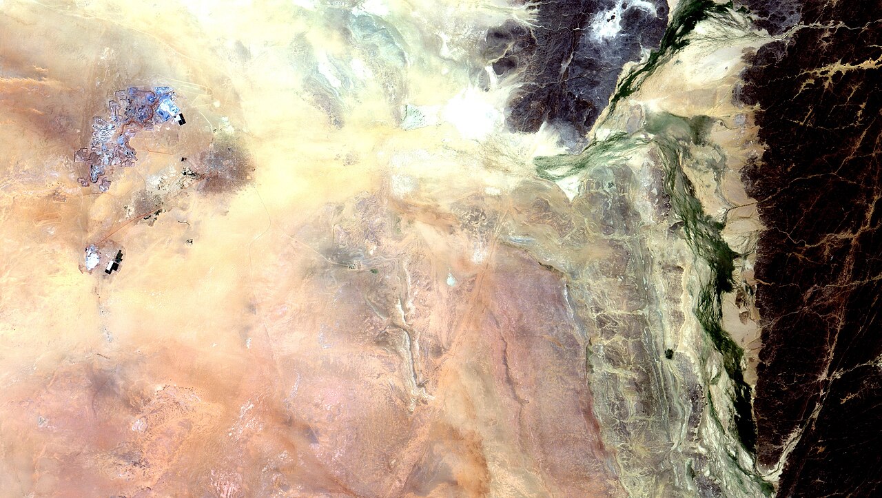
English: Minas de urânio da cidade de Arlit, Níger, próxima ao Maciço de Aïr, no deserto do Saara. A cava das minas aparece em tons azulados. A mancha escura à dir. é a área urbana de Arlit, com mais de 100 mil habitantes. Em amarelo e laranja as areias do deserto / Arlit, Niger, uranium mines, near Aïr Mountains on the Sahara. Mine pits appear in blueish colors. Darker spot on the right is Arlit urban area, with +100 thousand people. Desert sands appears in yellow and orange.
Veja imagens recentes da região na série da Al Jazeera "Orphans of the Sahara" em / See recent imagens from region at "Orphans of the Sahara": www.youtube.com/watch?v=JBLMjGnJreg
Imagem / Image CBERS4 MUX Minas de Urânio de Arlit, Niger Coordenadas do centro da imagem / Image center: 18°44'39.6"N 7°19'30.8"E Data / Date: 02-10-2018 / 2018-02-10 RGB 765 (cor verdadeira / true color) Cena / Scene: 108 / 079 Autor / Author: Oton Barros (DSR/OBT/INPE) Imagem em HD / HD Image Visite-nos / Visit us: www.dsr.inpe.br |
| Date | |
| Source | https://www.flickr.com/photos/153282474@N02/30142758447/ |
| Author | Coordenação-Geral de Observação da Terra/INPE |
Licensing[edit]
This file is licensed under the Creative Commons Attribution-Share Alike 2.0 Generic license.
- You are free:
- to share – to copy, distribute and transmit the work
- to remix – to adapt the work
- Under the following conditions:
- attribution – You must give appropriate credit, provide a link to the license, and indicate if changes were made. You may do so in any reasonable manner, but not in any way that suggests the licensor endorses you or your use.
- share alike – If you remix, transform, or build upon the material, you must distribute your contributions under the same or compatible license as the original.
| This image was originally posted to Flickr by Coordenação-Geral de Observação da Terra/INPE at https://flickr.com/photos/153282474@N02/30142758447. It was reviewed on 9 April 2020 by FlickreviewR 2 and was confirmed to be licensed under the terms of the cc-by-sa-2.0. |
File history
Click on a date/time to view the file as it appeared at that time.
| Date/Time | Thumbnail | Dimensions | User | Comment | |
|---|---|---|---|---|---|
| current | 10:14, 9 April 2020 | | 3,263 × 1,843 (2.44 MB) | Jo-Jo Eumerus (talk | contribs) | Uploaded a work by Coordenação-Geral de Observação da Terra/INPE from https://www.flickr.com/photos/153282474@N02/30142758447/ with UploadWizard |
You cannot overwrite this file.
File usage on Commons
The following 2 pages use this file:
- Niger
- File:Minas de Urânio de Arlit Niger, África (30142758447).jpg (file redirect)
.jpg&redirect=no)
File usage on other wikis
The following other wikis use this file:
- Usage on fr.wikipedia.org