File:Nicobar Islands.jpg
Jump to navigation
Jump to search
No higher resolution available.
Nicobar_Islands.jpg (643 × 564 pixels, file size: 70 KB, MIME type: image/jpeg)
Captions
Captions
Add a one-line explanation of what this file represents
Summary[edit]
| Description |
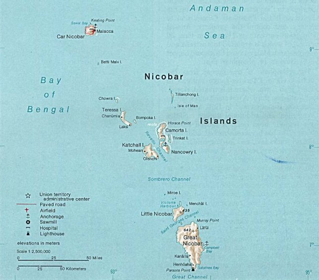
Deutsch: Karte der Inselgruppe der Nikobaren im Indischen Ozean
English: Map of the Nicobar Island in the Indian Ocean
Français : Carte d’îles Nicobar dans l’océan Indien |
| Date | |
| Source | http://www.lib.utexas.edu/maps/islands_oceans_poles/andaman_nicobar_76.jpg |
| Author | Taken from Perry-Castañeda Library (PCL), originally from CIA Indian Ocean Atlas |
| Other versions |
Licensing[edit]
| This image is a work of a Central Intelligence Agency employee, taken or made as part of that person's official duties. As a Work of the United States Government, this image or media is in the public domain in the United States.
|

|
File history
Click on a date/time to view the file as it appeared at that time.
| Date/Time | Thumbnail | Dimensions | User | Comment | |
|---|---|---|---|---|---|
| current | 22:33, 14 May 2005 | | 643 × 564 (70 KB) | Jeroen (talk | contribs) | From the Indian Ocean Atlas, published by the Central Intelligence Agency, 1976. From en:Image:Nicobar_Islands.jpg ''This image is a work of a Central Intelligence Agency employee, taken or made during the course of the person's official duties. As |
You cannot overwrite this file.
File usage on Commons
The following page uses this file:
File usage on other wikis
The following other wikis use this file:
- Usage on ace.wikipedia.org
- Usage on ar.wikipedia.org
- Usage on arz.wikipedia.org
- Usage on az.wikipedia.org
- Usage on be-tarask.wikipedia.org
- Usage on bg.wikipedia.org
- Usage on bn.wikipedia.org
- Usage on br.wikipedia.org
- Usage on ca.wikipedia.org
- Usage on ceb.wikipedia.org
- Usage on cs.wikipedia.org
- Usage on da.wikipedia.org
- Usage on de.wikipedia.org
- Usage on en.wikipedia.org
- Usage on eo.wikipedia.org
- Usage on es.wikipedia.org
- Usage on eu.wikipedia.org
- Usage on fa.wikipedia.org
- Usage on fi.wikipedia.org
- Usage on fi.wiktionary.org
- Usage on fr.wikipedia.org
- Usage on fr.wikinews.org
- Usage on gl.wikipedia.org
- Usage on gu.wikipedia.org
- Usage on hi.wikipedia.org
- Usage on id.wikipedia.org
- Usage on ilo.wikipedia.org
- Usage on it.wikipedia.org
- Usage on ja.wikipedia.org
- Usage on ka.wikipedia.org
- Usage on ko.wikipedia.org
View more global usage of this file.