File:Nicholas off the coast of Texas and Louisiana (MODIS 2021-09-16).jpg

Original file (7,803 × 6,639 pixels, file size: 6.52 MB, MIME type: image/jpeg)
Captions
Captions
Summary[edit]
.jpg&action=edit§ion=1)
| Description |
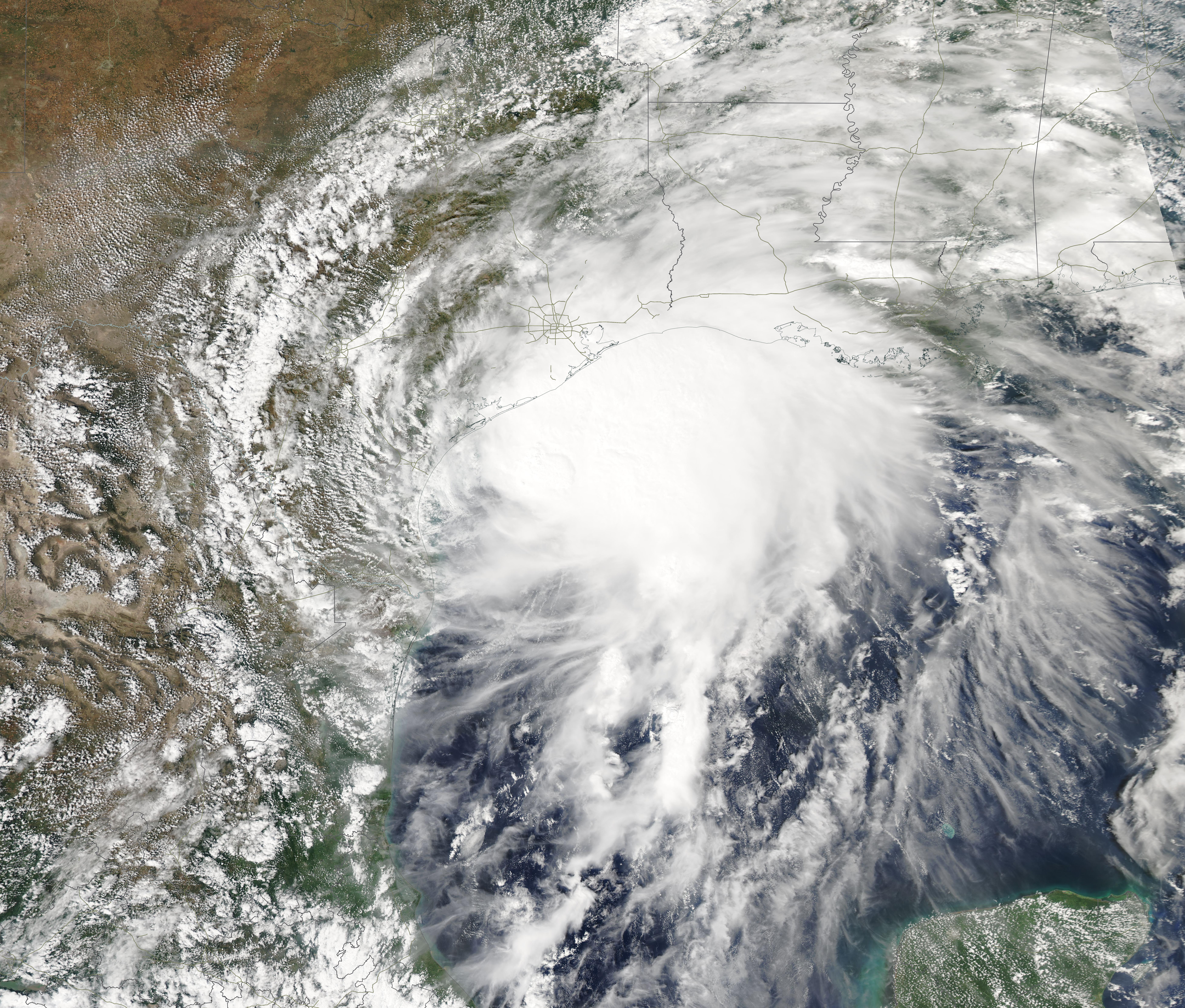
English: At about 1:30 a.m. EDT (0530 UTC) on September 14, Hurricane Nicholas made landfall on the eastern part of the Matagorda Peninsula, about 10 miles (15 km) west-southwest of Sargent Beach, Texas. The storm, which had strengthened to hurricane status only hours before landfall, brought torrential rainfall to parts of southeastern Texas and southwestern Louisiana on September 14 before weakening and stalling inland on September 15. By that date, the system had become a tropical depression that lingered over Louisiana, Mississippi, Alabama, and the Florida Panhandle, dousing the region that had recently been flooded by rains from Hurricane Ida.
Hurricane Nicholas came ashore carrying maximum sustained winds of 75 mph (120 km/h), placing it as a weak Category 1 storm on the Saffir-Simpson Hurricane Wind Scale. According to The Weather Channel, a WeatherFlow sensor at Matagorda Bay reported maximum sustained winds of 76 mph (122 km/h) and a gust of 95 mph (153 km/h). Storm surge of 3 to 6 feet (0.9 – 1.8 m) was recorded along the upper Texas coast and 9.85 inches (25 cm) of rain fell at Deer Park, Texas. Power was disrupted to more than 500,000 customers in southeastern Texas. The Moderate Resolution Imaging Spectroradiometer (MODIS) on board NASA’s Aqua satellite acquired a true-color image of Nicholas on September 13, when was crawling just off the Texas coast at Tropical Storm strength. The storm featured a cloud-filled eye and a nearly-symmetric shape. Convective bands reached over the southeastern Texas and Louisiana coast, bringing wind and rain to locations such as Galveston, Texas and Lake Charles, Louisiana. |
||
| Date | Taken on 13 September 2021 | ||
| Source |
Nicholas off the coast of Texas and Louisiana (direct link)
|
||
| Author | MODIS Land Rapid Response Team, NASA GSFC |
| This media is a product of the Aqua mission Credit and attribution belongs to the mission team, if not already specified in the "author" row |
Licensing[edit]
.jpg&action=edit§ion=2)
| This file is in the public domain in the United States because it was solely created by NASA. NASA copyright policy states that "NASA material is not protected by copyright unless noted". (See Template:PD-USGov, NASA copyright policy page or JPL Image Use Policy.) | ||
 |
Warnings:
|
File history
Click on a date/time to view the file as it appeared at that time.
| Date/Time | Thumbnail | Dimensions | User | Comment | |
|---|---|---|---|---|---|
| current | 18:46, 29 January 2024 | | 7,803 × 6,639 (6.52 MB) | OptimusPrimeBot (talk | contribs) | #Spacemedia - Upload of http://modis.gsfc.nasa.gov/gallery/images/image09162021_250m.jpg via Commons:Spacemedia |
You cannot overwrite this file.
File usage on Commons
There are no pages that use this file.
.jpg&oldid=846890716)