File:Newberry Crater National Volcanic Monument, Oregon (1290856867).jpg

Original file (1,600 × 1,200 pixels, file size: 164 KB, MIME type: image/jpeg)
Captions
Captions
Summary[edit]
.jpg&action=edit§ion=1)
| Description |
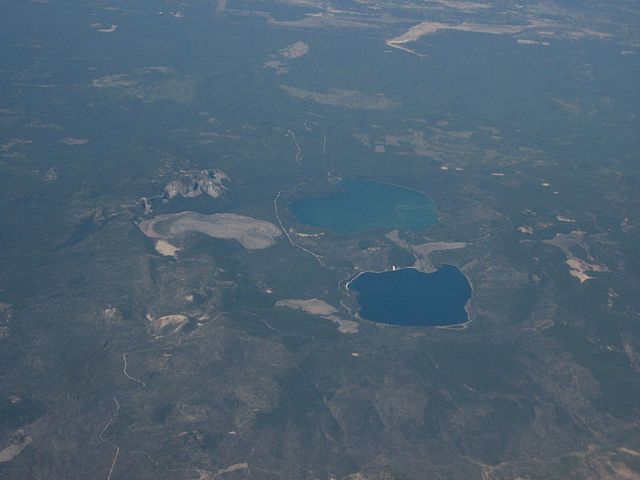
Newberry National Volcanic Monument was designated on November 5, 1990, to protect the area around the Newberry Volcano in the United States. It was created within the boundaries of the Deschutes National Forest and is managed by the U.S. Forest Service. It includes 50,000 acres (20,000 ha) of lakes, lava flows, and spectacular geologic features in central Oregon. The highest point within the monument is the summit Paulina Peak 7,985 ft (2,434 m), (2,434 m), with views of the Oregon Cascades and the high desert. Paulina Peak may be accessed by road during the summer months, and as the road is both steep and rough, with hairpin turns towards the summit, trailers or long vehicles are discouraged. The summit area of Newberry Volcano holds two alpine lakes full of trout, East Lake and Paulina Lake. The park is also home to Lava River Cave, Oregon's longest known lava tube, just south of Bend. The cave is easily accessed by U.S. Highway 97 and may be explored by lantern. Lava Butte, a 500-foot (150 m) cinder cone, is located next to U.S. Highway 97 south of Bend, next to the Lava Lands Visitor Center. The visitor center is under renovation, and is typically open during the summer. The monument also features a Lava Cast Forest, which is accessible via a 9-mile (14 km) dirt road from U.S. Highway 97. The Big Obsidian Flow, created 1,300 years ago, covers 700 acres (2.8 km2). The black, shiny obsidian field is easily accessible from good roads within the caldera, or a trail that traverses the flow. en.wikipedia.org/wiki/Newberry_National_Volcanic_Monument en.wikipedia.org/wiki/Wikipedia:Text_of_Creative_Commons_... |
| Date | |
| Source | Newberry Crater National Volcanic Monument, Oregon |
| Author | Ken Lund from Reno, Nevada, USA |
| Camera location | | View this and other nearby images on: OpenStreetMap |
|---|
.jpg¶ms=043.720001_N_-121.258506_E_globe:Earth_type:camera_source:Flickr_&language=en)
Licensing[edit]
.jpg&action=edit§ion=2)
- You are free:
- to share – to copy, distribute and transmit the work
- to remix – to adapt the work
- Under the following conditions:
- attribution – You must give appropriate credit, provide a link to the license, and indicate if changes were made. You may do so in any reasonable manner, but not in any way that suggests the licensor endorses you or your use.
- share alike – If you remix, transform, or build upon the material, you must distribute your contributions under the same or compatible license as the original.
| This image was originally posted to Flickr by Ken Lund at https://flickr.com/photos/75683070@N00/1290856867. It was reviewed on 3 December 2015 by FlickreviewR and was confirmed to be licensed under the terms of the cc-by-sa-2.0. |
File history
Click on a date/time to view the file as it appeared at that time.
| Date/Time | Thumbnail | Dimensions | User | Comment | |
|---|---|---|---|---|---|
| current | 21:54, 3 December 2015 | | 1,600 × 1,200 (164 KB) | INeverCry (talk | contribs) | Transferred from Flickr via Flickr2Commons |
You cannot overwrite this file.
File usage on Commons
There are no pages that use this file.
File usage on other wikis
The following other wikis use this file:
- Usage on ceb.wikipedia.org
- Usage on fr.wikipedia.org
- Usage on www.wikidata.org
.jpg&oldid=875350605)