File:Newberry-Yellowstone tracks.png
Newberry-Yellowstone_tracks.png (536 × 326 pixels, file size: 19 KB, MIME type: image/png)
Captions
Captions
Summary[edit]
| Description |
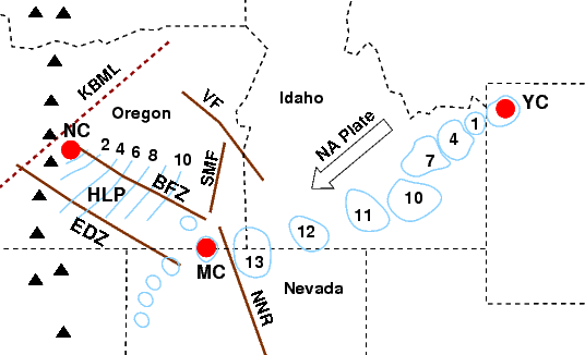
English: Diagram showing age progression of rhyolitic (silicic) lavas of the Newberry and Yellowstone Hotspot tracks (and related features). |
| Date | |
| Source | Own work |
| Author | J. Johnson |
Progression of ages of rhyolitic (silicic) lavas and calderas from McDermitt Caldera to Newberry and Yellowstone calderas (red circles: MC, NC, & YC). Numbers are ages in millions of years. KBML - Klamath—Blue Mountains Lineament, HLP - High Lava Plains, EDZ - Eugene—Denio Zone, BFZ - Brothers Fault Zone, SMF - Steens Mountain Fault, VF - Vale Fault, NNR - North Nevada Rift. White arrow shows direction of North American plate, edge of the craton is approximately along the Oregon—Idaho Border, triangles are Cascades volcanoes.
This image based on images and data from the following sources:
- Christiansen, Robert L.; Foulger, G. R.; Evans, John R. (2002-10). "Upper-mantle origin of the Yellowstone hotspot". GSA Bulletin 114 (10): 1245—1256. DOI:10.1130/0016-7606(2002)114.
- Coble, Matthew A.; Mahood, Gail A. (2008). "New geologic evidence for additional 16.5-15.5 Ma silicic calderas in northwest Nevada related to initial impingement of the Yellowstone hot spot, Collapse Calderas Workshop". IOP Conference Series: Earth and Environmental Science 3 (1). DOI:10.1088/1755-1307/3/1/012002.
- Jordan, Brennan T.; Grunder, Anita L.; Duncan, Robert A.; Deino, Alan L. (2004). "Geochronology of age-progressive volcanism of the Oregon High Lava Plains: Implications for the plume interpretation of Yellowstone". Journal of Geophysical Research 109 (B10202). DOI:10.1029/2003JB002776.
- Wagner, Lara; Forsyth, Donald W.; Fouch, Matthew J. ; James, David (2010). "Detailed three-dimensional shear wave velocity structure of the northwestern United States from Rayleigh wave tomography". Earth and Planetary Sciences Letters (article in press). DOI:10.1016/j.epsl.2010.09.005.
Licensing[edit]
- You are free:
- to share – to copy, distribute and transmit the work
- to remix – to adapt the work
- Under the following conditions:
- attribution – You must give appropriate credit, provide a link to the license, and indicate if changes were made. You may do so in any reasonable manner, but not in any way that suggests the licensor endorses you or your use.
- share alike – If you remix, transform, or build upon the material, you must distribute your contributions under the same or compatible license as the original.

|
Permission is granted to copy, distribute and/or modify this document under the terms of the GNU Free Documentation License, Version 1.2 or any later version published by the Free Software Foundation; with no Invariant Sections, no Front-Cover Texts, and no Back-Cover Texts. A copy of the license is included in the section entitled GNU Free Documentation License. |
File history
Click on a date/time to view the file as it appeared at that time.
| Date/Time | Thumbnail | Dimensions | User | Comment | |
|---|---|---|---|---|---|
| current | 20:21, 20 October 2010 | | 536 × 326 (19 KB) | J. Johnson (talk | contribs) | {{Information |Description={{en|1=Diagram showing age progression of rhyolitic (silicic) lavas of the Newberry and Yellowstone Hotspot tracks (and related features).}} |Source={{own}} |Author=J. Johnson |Date=2010-10-20 |Permission= |o |
You cannot overwrite this file.
File usage on Commons
There are no pages that use this file.
File usage on other wikis
The following other wikis use this file:
- Usage on de.wikipedia.org
- Usage on en.wikipedia.org
- Usage on it.wikipedia.org
- Usage on www.wikidata.org
- Geological maps of Idaho
- Geological maps of Nevada
- Geological maps of Wyoming
- Rhyolite
- Volcanological diagrams
- Diagrams of hot spots (volcanism)
- Maps of Yellowstone Caldera
- Newberry Caldera
- Geological maps of Oregon
- Calderas
- Yellowstone hotspot
- Faults in Idaho
- Faults in Oregon
- Maps of rifts
- Faults in Nevada
- Rhyolitic calderas
- Fault zones in the United States
- Quaternary magmatism of the United States
- Volcanological maps of Idaho
- Volcanological maps of Washington (state)
- Volcanological maps of Oregon