File:New Zealand-Map-by-Tuki-1798.jpg
Original file (2,413 × 3,217 pixels, file size: 483 KB, MIME type: image/jpeg)
Captions
Captions
Summary[edit]
| Description |
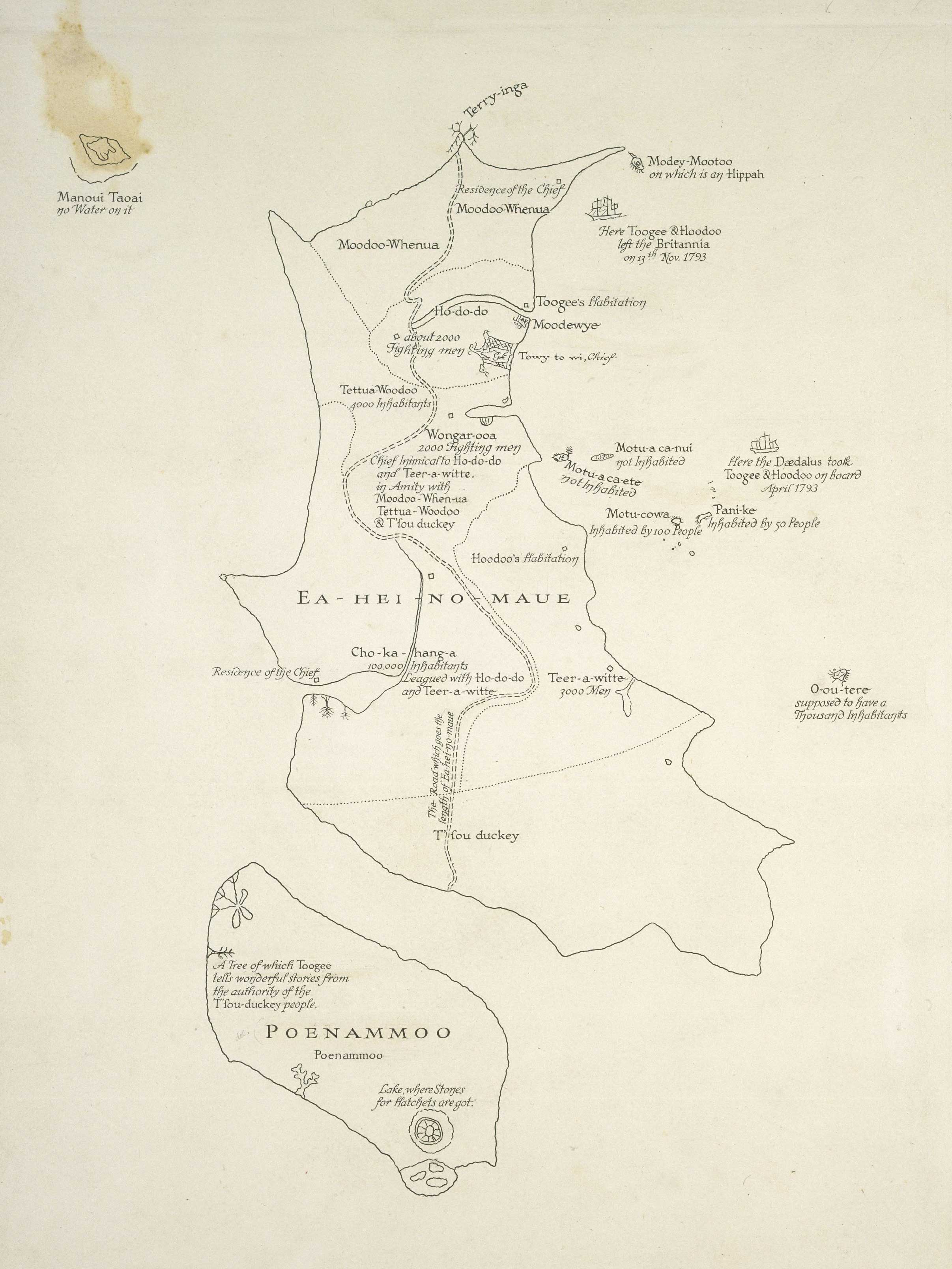
Map by Tuki Te Terenui Whare Pirau, whose name is spelled Toogee on the map. Drawn in 1793 and published in 'An Account of the English Colony in New South Wales', 1798 by Cadell & Davies. This is a copy of the oldest known manuscript map made by Maori, and the only example that covers all of both the North and South Islands. Does not cover Stewart Island (Rakiura). Includes social, mythical and political information especially about the upper North Island (where Tuki was from), with some brief comments on the South Island. Tells of the number of inhabitants in some of the iwi. The double dotted line across the North Island ends at Cape Reinga and represents the path the wairua (spirit of the dead) follows on its way to the Underworld. Drawn by Tuki after he and Huku were kidnapped from near the Bay of Islands and taken to Norfolk Island in order to teach convicts how to dress flax. The lieutenant govenor of Norfolk Island, Philip Gidley King's interest in their language and culture caused Tuki to draw a map of New Zealand. Tuki's home area was the far north of the North Auckland Peninsula, and this occupies a disproportionately large part of his delineation of the North Island. Tuki had only heard of the South Island from others, and it was drawn very small. |
| Date | |
| Source | Alexander Turnbull Library URL [1] Reference No. MapColl-CHA-2/1/9-Acc.36440 |
| Author | Tuki Te Terenui Whare Pirau, b. 1769. From 'An Account of the English Colony in New South Wales', 1798 by Cadell & Davies |
| Permission (Reusing this file) |
Out of Copyright worldwide |
Licensing[edit]
|
This work is in the public domain in its country of origin and other countries and areas where the copyright term is the author's life plus 100 years or fewer. | |
| This file has been identified as being free of known restrictions under copyright law, including all related and neighboring rights. | |
| Annotations | This image is annotated: View the annotations at Commons |
File history
Click on a date/time to view the file as it appeared at that time.
| Date/Time | Thumbnail | Dimensions | User | Comment | |
|---|---|---|---|---|---|
| current | 22:49, 20 July 2010 | | 2,413 × 3,217 (483 KB) | Kahuroa (talk | contribs) | {{Information |Description=Map by Tuki Te Terenui Whare Pirau, whose name is spelled Toogee on the map. From 'History of New South Wales', 1798 by Cadell & Davies, this is a copy of the oldest known map manuscript map made by Maori, and the only example t |
You cannot overwrite this file.
File usage on Commons
There are no pages that use this file.
File usage on other wikis
The following other wikis use this file:
- Usage on fr.wikipedia.org