File:New York - Finger Lakes region map with road shields.svg
From Wikimedia Commons, the free media repository
Jump to navigation
Jump to search

Size of this PNG preview of this SVG file: 800 × 584 pixels. Other resolutions: 320 × 234 pixels | 640 × 467 pixels | 1,024 × 748 pixels | 1,280 × 935 pixels | 2,560 × 1,869 pixels | 1,583 × 1,156 pixels.
Original file (SVG file, nominally 1,583 × 1,156 pixels, file size: 803 KB)
File information
Structured data
Captions
Captions
Add a one-line explanation of what this file represents
Summary[edit]
| DescriptionNew York - Finger Lakes region map with road shields.svg |
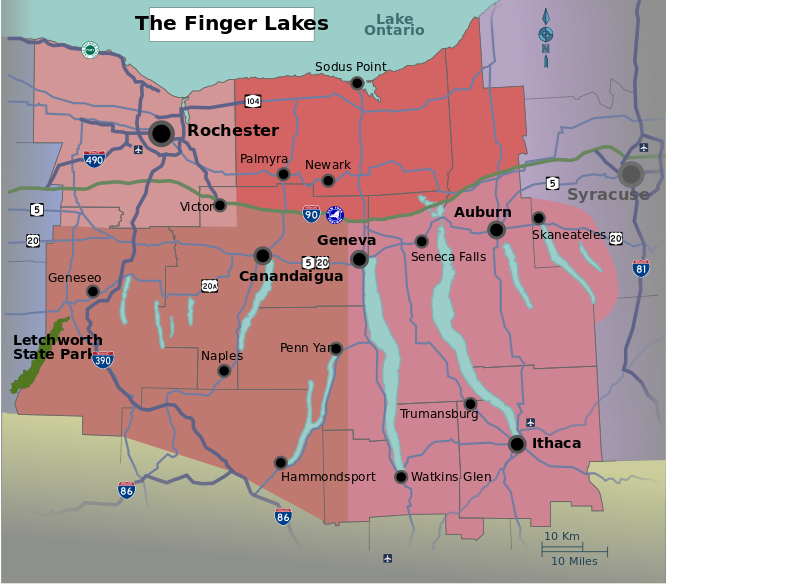
English: Map of the Finger Lakes region of New York, with major cities, highways, and airports marked. Created from public domain sources: NASA World Wind (USGS Maps), http://commons.wikimedia.org/wiki/Image:New York State Route 104 map.png, and http://www.lrb.usace.army.mil/brochure/images/new%202003/letch-park%20map2.gif. |
| Date | 9 June 2008 (original upload date) |
| Source | Own work |
| Author | User: (WT-shared) LtPowers at wts wikivoyage |
| Other versions |
Licensing[edit]
This file is licensed under the Creative Commons Attribution-Share Alike 4.0 International, 3.0 Unported, 2.5 Generic, 2.0 Generic and 1.0 Generic license.
- You are free:
- to share – to copy, distribute and transmit the work
- to remix – to adapt the work
- Under the following conditions:
- attribution – You must give appropriate credit, provide a link to the license, and indicate if changes were made. You may do so in any reasonable manner, but not in any way that suggests the licensor endorses you or your use.
- share alike – If you remix, transform, or build upon the material, you must distribute your contributions under the same or compatible license as the original.
Original upload log[edit]
| This file was imported from Wikivoyage WTS. |
The original description page was here. All following user names refer to wts.wikivoyage-old.
- 2008-06-09 20:16 (WT-shared) LtPowers[dead link] 1583×1156 (820518 bytes) {{en|Map of the [[en:Finger Lakes|]] region of [[en:New York (state)|]], with major cities, highways, and airports marked. Created from pub (Import from wikitravel.org/shared)
- 2008-06-17 15:40 (WT-shared) LtPowers[dead link] 1583×1156 (770269 bytes) Remove legend per discussion at the English Travellers' Pub. Also expand region to include Hammondsport and Skaneateles. (Import from wikitravel.org/shared)
- 2008-06-17 15:49 (WT-shared) LtPowers[dead link] 1583×1156 (770941 bytes) Fix layers in SVG, no change to output. (Import from wikitravel.org/shared)
- 2008-07-14 21:04 (WT-shared) LtPowers[dead link] 1583×1156 (776533 bytes) Swap "Naples" and "Newark". (Import from wikitravel.org/shared)
- 2009-02-22 20:42 (WT-shared) LtPowers[dead link] 1583×1156 (818199 bytes) Add Route 36 (Import from wikitravel.org/shared)
File history
Click on a date/time to view the file as it appeared at that time.
| Date/Time | Thumbnail | Dimensions | User | Comment | |
|---|---|---|---|---|---|
| current | 20:23, 30 April 2013 |  | 1,583 × 1,156 (803 KB) | PerryPlanet (talk | contribs) | altered region colors and text size |
| 19:03, 30 April 2013 |  | 1,583 × 1,156 (802 KB) | PerryPlanet (talk | contribs) | Uploading new version with regions marked | |
| 03:13, 16 December 2012 |  | 1,583 × 1,156 (799 KB) | OgreBot (talk | contribs) | (BOT): Reverting to most recent version before archival | |
| 03:13, 16 December 2012 |  | 1,583 × 1,156 (758 KB) | OgreBot (talk | contribs) | (BOT): Uploading old version of file from wts.wikivoyage; originally uploaded on 2008-07-14 21:04:43 by (WT-shared) LtPowers | |
| 03:13, 16 December 2012 |  | 1,583 × 1,156 (753 KB) | OgreBot (talk | contribs) | (BOT): Uploading old version of file from wts.wikivoyage; originally uploaded on 2008-06-17 15:49:03 by (WT-shared) LtPowers | |
| 03:12, 16 December 2012 |  | 1,583 × 1,156 (752 KB) | OgreBot (talk | contribs) | (BOT): Uploading old version of file from wts.wikivoyage; originally uploaded on 2008-06-17 15:40:39 by (WT-shared) LtPowers | |
| 03:12, 16 December 2012 |  | 1,583 × 1,156 (801 KB) | OgreBot (talk | contribs) | (BOT): Uploading old version of file from wts.wikivoyage; originally uploaded on 2008-06-09 20:16:53 by (WT-shared) LtPowers | |
| 10:50, 1 December 2012 |  | 1,583 × 1,156 (799 KB) | MGA73bot2 (talk | contribs) | {{BotMoveToCommons|wts.oldwikivoyage|year={{subst:CURRENTYEAR}}|month={{subst:CURRENTMONTHNAME}}|day={{subst:CURRENTDAY}}}} == {{int:filedesc}} == {{Information |description={{en|Map of the Finger Lakes region of [[:wts::en:Ne... | |
| 20:26, 1 July 2010 |  | 1,583 × 1,156 (605 KB) | DieBucheBot (talk | contribs) | Trying to fix SVG using scour | |
| 20:16, 17 May 2009 |  | 1,583 × 1,156 (799 KB) | Cirt (talk | contribs) | == Summary == {{Information |Description=Map of the Finger Lakes region of New York, with major cities, highways, and airports marked. Created from public domain sources: NASA World Wind (USGS Maps), http://commons.wikimedia.org/wiki/Image:New_York_State_ |
You cannot overwrite this file.
File usage on Commons
The following 2 pages use this file:
Metadata
This file contains additional information such as Exif metadata which may have been added by the digital camera, scanner, or software program used to create or digitize it. If the file has been modified from its original state, some details such as the timestamp may not fully reflect those of the original file. The timestamp is only as accurate as the clock in the camera, and it may be completely wrong.
| Width | 1266pt |
|---|---|
| Height | 925pt |