File:New 2000 black density.gif
Jump to navigation
Jump to search

Size of this preview: 776 × 600 pixels. Other resolutions: 311 × 240 pixels | 621 × 480 pixels | 994 × 768 pixels | 1,280 × 989 pixels | 2,604 × 2,012 pixels.
Original file (2,604 × 2,012 pixels, file size: 620 KB, MIME type: image/gif)
Captions
Captions
Add a one-line explanation of what this file represents

|
This ethnographic map image could be re-created using vector graphics as an SVG file. This has several advantages; see Commons:Media for cleanup for more information. If an SVG form of this image is available, please upload it and afterwards replace this template with
{{vector version available|new image name}}.
It is recommended to name the SVG file “New 2000 black density.svg”—then the template Vector version available (or Vva) does not need the new image name parameter. |
Summary[edit]
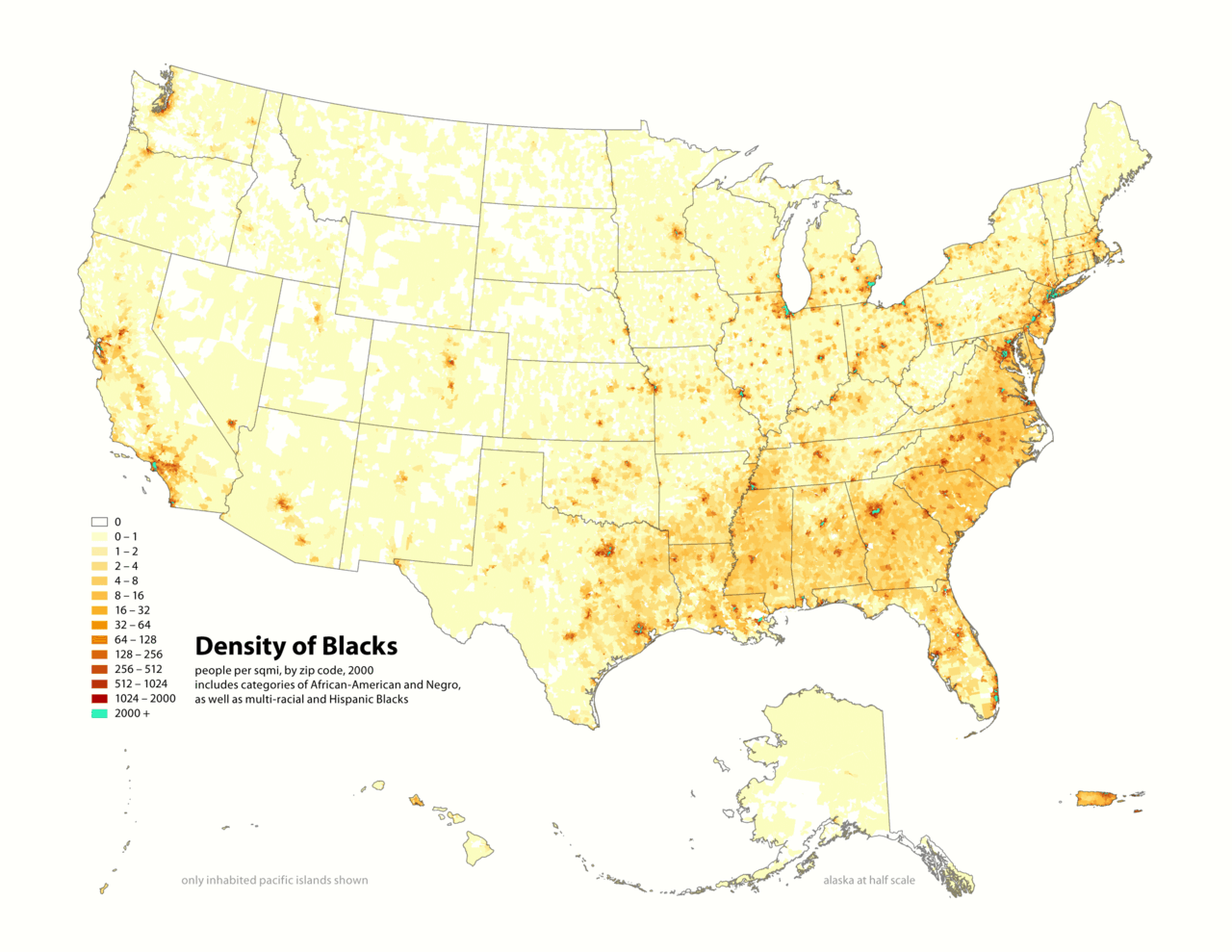
Map of contiguous US, showing density of self-reported "Black" population, in persons per square mile, by census tract, 2000. Data source: US Census.
I (user:Citynoice) am the designer and creator of this map and license it under the Creative Commons Attribution ShareAlike 2.5 License.
similar maps:
- w:Image:New 2000 asian density.gif
- w:Image:New 2000 asian percent.gif
- w:Image:New 2000 black density.gif
- w:Image:New 2000 black percent.gif
- w:Image:New 2000 hawaiian density.gif
- w:Image:New 2000 hawaiian percent.gif
- w:Image:New 2000 hispanic density.gif
- w:Image:New 2000 hispanic percent.gif
- w:Image:New 2000 indian density.gif
- w:Image:New 2000 indian percent.gif
- w:Image:New 2000 white density.gif
- w:Image:New 2000 white percent.gif
Licensing[edit]
This file is licensed under the Creative Commons Attribution-Share Alike 2.5 Generic license.
- You are free:
- to share – to copy, distribute and transmit the work
- to remix – to adapt the work
- Under the following conditions:
- attribution – You must give appropriate credit, provide a link to the license, and indicate if changes were made. You may do so in any reasonable manner, but not in any way that suggests the licensor endorses you or your use.
- share alike – If you remix, transform, or build upon the material, you must distribute your contributions under the same or compatible license as the original.
File history
Click on a date/time to view the file as it appeared at that time.
| Date/Time | Thumbnail | Dimensions | User | Comment | |
|---|---|---|---|---|---|
| current | 19:14, 1 May 2010 | | 2,604 × 2,012 (620 KB) | Citynoise (talk | contribs) | Added Alaska, Hawaii, and Territories. Also changed from tracts to zip codes. |
| 13:40, 25 September 2006 |  | 1,012 × 691 (99 KB) | CyberAngel (talk | contribs) | == Dettagli == {{Information| |Description={{en}} '''w:Republic of the New Afrika''' (RNA). Map of contiguous US, showing density of self-reported "Black" population, in persons per square mile, by census tract, 2000. ''Data source:'' US Census. {{it} |
You cannot overwrite this file.
File usage on Commons
There are no pages that use this file.
File usage on other wikis
The following other wikis use this file:
- Usage on de.wikiversity.org
- Usage on en.wikipedia.org
- Usage on fa.wikipedia.org
- Usage on fr.wikipedia.org
- Usage on gl.wikipedia.org
- Usage on it.wikipedia.org
- Usage on ja.wikipedia.org
- Usage on nl.wikipedia.org
- Usage on pl.wikipedia.org
- Usage on pt.wikipedia.org
- Usage on tl.wikipedia.org
- Usage on ur.wikipedia.org