File:NeutralZone1990-ar.jpg
Jump to navigation
Jump to search
No higher resolution available.
NeutralZone1990-ar.jpg (404 × 442 pixels, file size: 57 KB, MIME type: image/jpeg)
Captions
Captions
Add a one-line explanation of what this file represents
Summary[edit]
| Description |
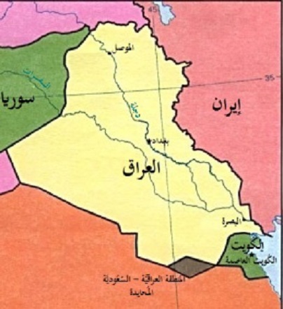
العربية: خريطة تُظهر المنطقة المُحيادة بين الجُمهوريَّة العراقيَّة والمملكة العربيَّة السُعُوديَّة، كما تظهر بها الكُويت وإيران وسوريا. |
| Date | |
| Source | Derivative from: this file |
| Author |
|
| Other versions | English |
| This is a retouched picture, which means that it has been digitally altered from its original version. Modifications: Translated to Arabic - عُرِبَت. The original can be viewed here: NeutralZone1990.jpg:
|
Licensing[edit]
| This image is a work of a Central Intelligence Agency employee, taken or made as part of that person's official duties. As a Work of the United States Government, this image or media is in the public domain in the United States.
|

|
File history
Click on a date/time to view the file as it appeared at that time.
| Date/Time | Thumbnail | Dimensions | User | Comment | |
|---|---|---|---|---|---|
| current | 12:15, 28 January 2017 | | 404 × 442 (57 KB) | باسم (talk | contribs) | User created page with UploadWizard |
You cannot overwrite this file.
File usage on Commons
There are no pages that use this file.
File usage on other wikis
The following other wikis use this file:
- Usage on ar.wikipedia.org