File:Naturraumkarte Oberlausitz.png
Jump to navigation
Jump to search

Size of this preview: 800 × 510 pixels. Other resolutions: 320 × 204 pixels | 640 × 408 pixels | 1,024 × 653 pixels | 1,280 × 816 pixels | 2,560 × 1,632 pixels | 4,129 × 2,633 pixels.
Original file (4,129 × 2,633 pixels, file size: 10.13 MB, MIME type: image/png)
Captions
Captions
Add a one-line explanation of what this file represents
Summary[edit]
| Description |
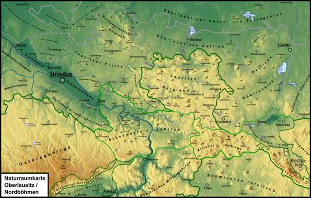
Deutsch: Naturraumkarte der Oberlausitz mit Oberlausitzer Gebirge, Lausitzer Bergland, Östlicher Oberlausitz (nebst Tittauer Becken), Westlausitzer Hügel- und Bergland und Oberlausitzer Gefilde; überdies sind Elbsandsteingebirge, Östliches Erzgebirgsvorland und Dresdner Elbtalweitung komplett enthalten. Naturraumgrenzen: Dunkelgrün für Grundgebirge, Hellgrün für Kreide und Grau für Quartär. |
| Date | |
| Source |
Own work /
|
| Author | Elop, Relief: Maps-for-free |
Licensing[edit]
I, the copyright holder of this work, hereby publish it under the following license:
This file is licensed under the Creative Commons Attribution-Share Alike 3.0 Unported license.
- You are free:
- to share – to copy, distribute and transmit the work
- to remix – to adapt the work
- Under the following conditions:
- attribution – You must give appropriate credit, provide a link to the license, and indicate if changes were made. You may do so in any reasonable manner, but not in any way that suggests the licensor endorses you or your use.
- share alike – If you remix, transform, or build upon the material, you must distribute your contributions under the same or compatible license as the original.
File history
Click on a date/time to view the file as it appeared at that time.
| Date/Time | Thumbnail | Dimensions | User | Comment | |
|---|---|---|---|---|---|
| current | 11:16, 24 January 2021 | | 4,129 × 2,633 (10.13 MB) | Elop (talk | contribs) | |
| 13:48, 16 January 2021 |  | 4,129 × 2,633 (10.02 MB) | Elop (talk | contribs) | ||
| 11:30, 10 January 2021 |  | 4,130 × 2,633 (9.91 MB) | Elop (talk | contribs) | == {{int:filedesc}} == {{Information |Description ={{de|1= Naturraumkarte der de:Oberlausitz mit de:Oberlausitzer Gebirge, de:Lausitzer Bergland, Östlicher Oberlausitz (nebst Tittauer Becken), Westlausitzer Hügel- und Bergland und de:Oberlausitzer Gefilde; überdies sind de:Elbsandsteingebirge, de:Östliches Erzgebirgsvorland und de:Dresdner Elbtalweitung komplett enthalten. }} |Source ={{own}} / * Günther... |
You cannot overwrite this file.
File usage on Commons
There are no pages that use this file.
File usage on other wikis
The following other wikis use this file:
- Usage on de.wikipedia.org
- Usage on de.wikibooks.org