File:Naturraumkarte Fichtelgebirge Hufeisen.png
Jump to navigation
Jump to search

Size of this preview: 618 × 599 pixels. Other resolutions: 248 × 240 pixels | 495 × 480 pixels | 949 × 920 pixels.
Original file (949 × 920 pixels, file size: 1.07 MB, MIME type: image/png)
Captions
Captions
Add a one-line explanation of what this file represents
Summary[edit]
| Description |
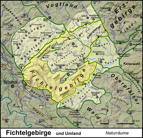
Deutsch: Naturraumkarte des Fichtelgebirges, mit seiner markanten Hufeisenform die Selb-Wunsiedeler Hochfläche umfassend; dazu Elstergebirge sowie die angrenzenden Landschaften Naab-Wondreb-Senke, Münchberger Hochfläche und Egerbecken. Aufgehellt sind überdies die geologisch Fichtel- und Erzgebirge entsprechenden Teile des Oberen Vogtlandes sowie, im südwestlich anschließenden Oberpfälzischen Hügelland, die Basaltkuppen Rauher Kulm (681 m), Schloßberg| (641 m), Parkstein (595 m) und Anzenberg (593 m). |
| Date | |
| Source |
This file was derived from: Naturraumkarte Fichtelgebirge.png:  by Elop by Elop |
| Author |
Chianti *Abgeleitet von File:Flussgebietskarte Deutschland.png (für weitere Referenzen siehe dort); unmittelbarer Ausschnitt von File:Naturraumkarte Thueringisch-Fraenkisches Mittelgebirge mit Vogtland.png *Relief: Alexrk2 |
| Other versions | Siehe Galerie |
I, the copyright holder of this work, hereby publish it under the following license:
This file is licensed under the Creative Commons Attribution 3.0 Unported license.
- You are free:
- to share – to copy, distribute and transmit the work
- to remix – to adapt the work
- Under the following conditions:
- attribution – You must give appropriate credit, provide a link to the license, and indicate if changes were made. You may do so in any reasonable manner, but not in any way that suggests the licensor endorses you or your use.
File history
Click on a date/time to view the file as it appeared at that time.
| Date/Time | Thumbnail | Dimensions | User | Comment | |
|---|---|---|---|---|---|
| current | 16:23, 20 July 2019 | | 949 × 920 (1.07 MB) | Chianti (talk | contribs) | {{Information |description ={{de|1=Naturraumkarte des Fichtelgebirges, mit seiner markanten Hufeisenform die Selb-Wunsiedeler Hochfläche umfassend; dazu Elstergebirge sowie die angrenzenden Landschaften Naab-Wondreb-Senke, Münchberger Hochfläche und Egerbecken. Aufgehellt sind überdies die geologisch Fichtel- und Erzgebirge entsprechen... |
You cannot overwrite this file.
File usage on Commons
The following 2 pages use this file:
File usage on other wikis
The following other wikis use this file:
- Usage on de.wikipedia.org