File:Natal main line 1910.svg
Jump to navigation
Jump to search

Size of this PNG preview of this SVG file: 532 × 599 pixels. Other resolutions: 213 × 240 pixels | 426 × 480 pixels | 682 × 768 pixels | 909 × 1,024 pixels | 1,819 × 2,048 pixels | 730 × 822 pixels.
Original file (SVG file, nominally 730 × 822 pixels, file size: 592 KB)
Captions
Captions
Add a one-line explanation of what this file represents
| Description |
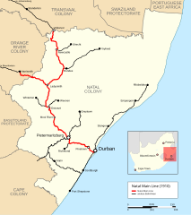
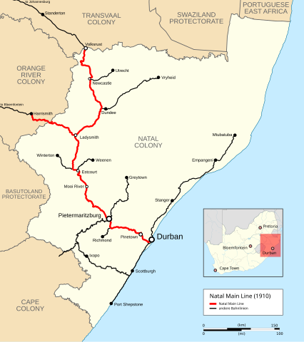
English: Map of the Natal main lin as it was in 1910 on the eve of the creation of the Union of South Africa. |
|||
| Date | ||||
| Source |
|
|||
| Author |
|
|||
| Permission (Reusing this file) |
I, the copyright holder of this work, hereby publish it under the following license: This file is licensed under the Creative Commons Attribution-Share Alike 3.0 Unported license.
|
File history
Click on a date/time to view the file as it appeared at that time.
| Date/Time | Thumbnail | Dimensions | User | Comment | |
|---|---|---|---|---|---|
| current | 09:58, 22 May 2016 | | 730 × 822 (592 KB) | Pechristener (talk | contribs) | Branchline to Harismith added |
| 22:35, 7 March 2016 |  | 730 × 822 (589 KB) | Pechristener (talk | contribs) | {{Information |Description ={{en|1=Map of the Natal main lin as it was in 1910 on the eve of the creation of the Union of South Africa.}} |Source = * Basemap [[:File:Natal railways map 1910.svg|Natal railways m... |
You cannot overwrite this file.
File usage on Commons
The following 9 pages use this file:
- User:Chumwa/OgreBot/Potential transport maps/2016 May 21-31
- User:Chumwa/OgreBot/Public transport information/2016 March 1-10
- User:Chumwa/OgreBot/Public transport information/2016 May 21-31
- User:Chumwa/OgreBot/Transport Maps/2016 March 1-10
- User:Chumwa/OgreBot/Transport Maps/2016 May 21-31
- User:Chumwa/OgreBot/Travel and communication maps/2016 March 1-10
- User:Chumwa/OgreBot/Travel and communication maps/2016 May 21-31
- User:Pechristener
- Category:Natal Main Line
File usage on other wikis
The following other wikis use this file:
- Usage on de.wikipedia.org
- Usage on www.wikidata.org