File:Nakayama tunnel map ja.png
Jump to navigation
Jump to search

Size of this preview: 468 × 600 pixels. Other resolutions: 187 × 240 pixels | 374 × 480 pixels | 599 × 768 pixels | 799 × 1,024 pixels | 2,135 × 2,736 pixels.
Original file (2,135 × 2,736 pixels, file size: 1.09 MB, MIME type: image/png)
Captions
Captions
Add a one-line explanation of what this file represents

|
This road map image could be re-created using vector graphics as an SVG file. This has several advantages; see Commons:Media for cleanup for more information. If an SVG form of this image is available, please upload it and afterwards replace this template with
{{vector version available|new image name}}.
It is recommended to name the SVG file “Nakayama tunnel map ja.svg”—then the template Vector version available (or Vva) does not need the new image name parameter. |
Summary[edit]
| Description |
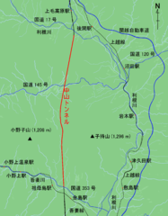
English: Map of Nakayama Tunnel on the Joetsu Shinkansen and roads and rivers nearby
日本語: 上越新幹線中山トンネルと、その周辺の川や道路との位置関係を示す地図 |
| Date | |
| Source | Map based on OpenStreetMap, rendering by Kosmos, some information added by Tam0031 |
| Author | OpenStreetMap contributors |
| Description |
This map was created from OpenStreetMap project data, collected by the community. This map may be incomplete, and may contain errors. Don't rely solely on it for navigation. |
| Date | (see file history) |
| Source | openstreetmap.org |
| Creator |
OpenStreetMap contributors |
| Permission (Reusing this file) |
OpenStreetMap data and maps are licensed under the Creative Commons Attribution-ShareAlike 2.0 license (CC-BY-SA 2.0). This file is licensed under the Creative Commons Attribution-Share Alike 2.0 Generic license.
|
| Georeferencing | If inappropriate please set warp_status = skip to hide. |
Licensing[edit]
This file is licensed under the Creative Commons Attribution-Share Alike 3.0 Unported license.
- You are free:
- to share – to copy, distribute and transmit the work
- to remix – to adapt the work
- Under the following conditions:
- attribution – You must give appropriate credit, provide a link to the license, and indicate if changes were made. You may do so in any reasonable manner, but not in any way that suggests the licensor endorses you or your use.
- share alike – If you remix, transform, or build upon the material, you must distribute your contributions under the same or compatible license as the original.
File history
Click on a date/time to view the file as it appeared at that time.
| Date/Time | Thumbnail | Dimensions | User | Comment | |
|---|---|---|---|---|---|
| current | 16:21, 24 August 2012 | | 2,135 × 2,736 (1.09 MB) | Tam0031 (talk | contribs) | add direction arrow |
| 14:58, 22 July 2012 |  | 2,135 × 2,736 (1.06 MB) | Tam0031 (talk | contribs) | {{Information |Description={{En|Map showing Nakayama tunnel of Joetsu Shinkansen and relationship with nereby roads and rivers.}}{{Ja|上越新幹線中山トンネルと、その周辺の川や道路との位置関係を示す地図}} |Source=Map base... |
You cannot overwrite this file.
File usage on Commons
There are no pages that use this file.
File usage on other wikis
The following other wikis use this file:
- Usage on ja.wikipedia.org
- Usage on zh.wikipedia.org