File:Nagorno-Karabakh conflict map (pre-2020).png
Jump to navigation
Jump to search
Size of this preview: 800 × 400 pixels. Other resolutions: 320 × 160 pixels | 640 × 320 pixels | 1,000 × 500 pixels.
Original file (1,000 × 500 pixels, file size: 130 KB, MIME type: image/png)
Captions
Captions
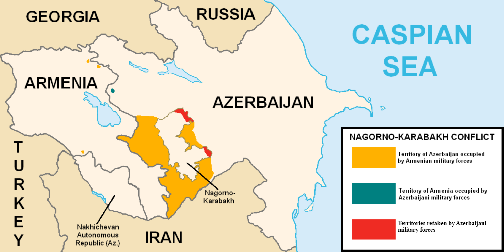
Map of the Nagorno-Karabakh conflict prior to 2020

|
This map image could be re-created using vector graphics as an SVG file. This has several advantages; see Commons:Media for cleanup for more information. If an SVG form of this image is available, please upload it and afterwards replace this template with
{{vector version available|new image name}}.
It is recommended to name the SVG file “Nagorno-Karabakh conflict map (pre-2020).svg”—then the template Vector version available (or Vva) does not need the new image name parameter. |
Summary[edit]
.png&action=edit§ion=1)
| Description |
English: This map describes the situation in the disputed Nagorno-Karabakh region prior to the 2020 war. The region is internationally recognized as part of Azerbaijan but partly governed by the de facto independent Republic of Artsakh. The image is a modified version of MarshallBagramyan's map. |
| Date | |
| Source | File:Artsakh Occupation Map.png |
| Author | Elnur Hajiyev |
Licensing[edit]
.png&action=edit§ion=2)
| This work has been released into the public domain by its author, Elnurvl. This applies worldwide. In some countries this may not be legally possible; if so: |
File history
Click on a date/time to view the file as it appeared at that time.
| Date/Time | Thumbnail | Dimensions | User | Comment | |
|---|---|---|---|---|---|
| current | 01:18, 7 August 2020 | | 1,000 × 500 (130 KB) | Elnurvl (talk | contribs) | Uploaded a work by Marshall Bagramyan from https://en.wikipedia.org/wiki/File:Artsakh_Occupation_Map.png with UploadWizard |
You cannot overwrite this file.
File usage on Commons
The following page uses this file:
- File:Transcaucasia Map.png (file redirect)
File usage on other wikis
The following other wikis use this file:
- Usage on en.wikipedia.org
- Usage on es.wikipedia.org
- Usage on eu.wikipedia.org
- Usage on ga.wikipedia.org
- Usage on he.wikipedia.org
- Usage on pt.wikipedia.org
- Usage on ru.wikipedia.org
- Usage on sr.wikipedia.org
.png&oldid=699282595)