File:NWFP and FATA.jpg
Jump to navigation
Jump to search

Size of this preview: 535 × 599 pixels. Other resolutions: 214 × 240 pixels | 428 × 480 pixels | 686 × 768 pixels | 914 × 1,024 pixels | 1,828 × 2,048 pixels | 6,325 × 7,085 pixels.
Original file (6,325 × 7,085 pixels, file size: 1.96 MB, MIME type: image/jpeg)
Captions
Captions
Add a one-line explanation of what this file represents
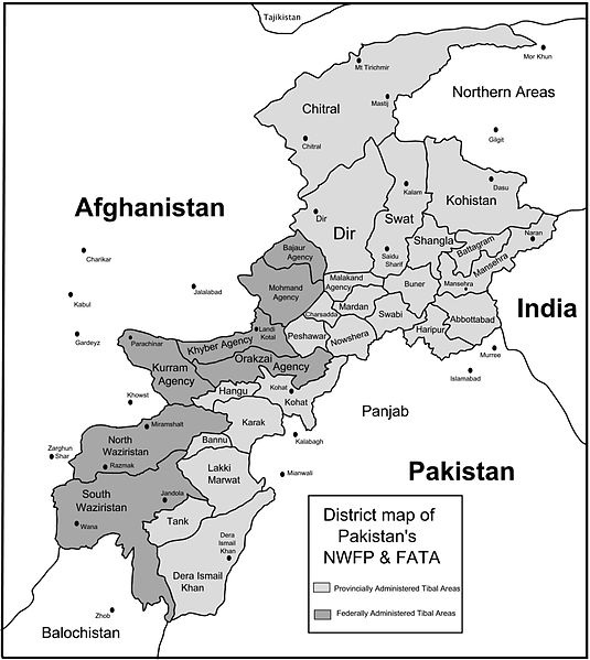
| Description | Map of Pakistan's North-West Frontier Province and Federally Administered Tribal Areas. |
| Date | |
| Source | self-made using map provided here at en.wikinews.org with permission for derivative work by Riaz Hakeem. |
| Author | Ed Brown as user Edbrown05 |
| Permission (Reusing this file) |
PD |
| Other versions | Image:Map showing NWFP and FATA.png |
This file is licensed under the Creative Commons Attribution 2.5 Generic license.
- You are free:
- to share – to copy, distribute and transmit the work
- to remix – to adapt the work
- Under the following conditions:
- attribution – You must give appropriate credit, provide a link to the license, and indicate if changes were made. You may do so in any reasonable manner, but not in any way that suggests the licensor endorses you or your use.

|
This file has been superseded by Map showing NWFP and FATA.png. It is recommended to use the other file. Please note that deleting superseded images requires consent. Reason to use the other file: "bad jpg vs good png"
|

|
File history
Click on a date/time to view the file as it appeared at that time.
| Date/Time | Thumbnail | Dimensions | User | Comment | |
|---|---|---|---|---|---|
| current | 08:55, 2 May 2007 | | 6,325 × 7,085 (1.96 MB) | Edbrown05~commonswiki (talk | contribs) | {{Information |Description= |Source= |Date= |Author= }} |
| 08:40, 2 May 2007 |  | 6,325 × 7,085 (1.95 MB) | Edbrown05~commonswiki (talk | contribs) | {{Information |Description= |Source= |Date= |Author= }} |
You cannot overwrite this file.
File usage on Commons
There are no pages that use this file.
File usage on other wikis
The following other wikis use this file:
- Usage on azb.wikipedia.org
- Usage on en.wikipedia.org