File:NS Plan T - ter hoogte van Papekop - Utrecht - 10 juli 2008 (23054423903).jpg

Original file (3,648 × 2,052 pixels, file size: 7.67 MB, MIME type: image/jpeg)
Captions
Captions
Summary[edit]
.jpg&action=edit§ion=1)
| Description |
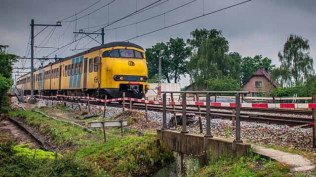
Materieel '64 (Mat '64), soms Standaard Stoptrein of Apekop genoemd, is de niet-officiële benaming van een type elektrisch treinstelmaterieel van de Nederlandse Spoorwegen. Het heeft - net als het sinds 1996 buiten dienst gestelde Materieel '54 (Hondekop) - een bolle neus ter bescherming van de machinist, maar deze steekt minder ver uit en is gelijk aan de neus van het buiten dienst gestelde materieel Plan U met dieselelektrische aandrijving. Het materieel bestaat uit zelfstandige vier- en tweedelige treinstellen, officieel aangeduid als respectievelijk Plan T en Plan V. Plan T is, afgezien van het prototype 501, in drie deelseries geleverd in 1964-1965. Alle treinstellen zijn voor sloop afgevoerd op een na, treinstel 526, dat ook niet meer in gebruik is. Plan V is in 13 deelseries geleverd in tien jaar tijd tussen 1966 en 1976. Het eerste stel werd al afgevoerd voordat de laatste stellen werden geleverd en de laatste 2 series V12 en V13 zijn even oud of zelfs nieuwer dan de oudste stellen SGM. Voor stel 802 werd in 1976 een nieuwe bak gebouwd ter vervanging van een bak met onherstelbare schade. Het stel 878 werd in 1976 na slechts 2,5 jaar dienst, als gevolg van brandschade een jaar eerder, afgevoerd in 1978 gevolgd door de 420 na een zware aanrijding. Daarna volgde in 1983 en 1987 de bakken van de 959. Inmiddels zijn alle stellen uit de series V1-V3, en V7-V12 buiten dienst gesteld en resteren alleen nog tweedelige stellen uit de deelseries V4-V6 en V13. Deze tweedelige stellen worden, in steeds afnemende aantallen, op een klein deel van de geëlektrificeerde baanvakken in Nederland ingezet en zijn volgens de officiële materieelverdeling alleen nog aan te treffen op een viertal spoorlijnen buiten de Randstad. Tekst: Wikipedia. |
| Date | |
| Source | NS Plan T - ter hoogte van Papekop - Utrecht - 10 juli 2008 |
| Author | Frans Berkelaar |
| Camera location | | View this and other nearby images on: OpenStreetMap |
|---|
.jpg¶ms=052.046561_N_0004.851908_E_globe:Earth_type:camera_source:Flickr_&language=en)
Licensing[edit]
.jpg&action=edit§ion=2)
- You are free:
- to share – to copy, distribute and transmit the work
- to remix – to adapt the work
- Under the following conditions:
- attribution – You must give appropriate credit, provide a link to the license, and indicate if changes were made. You may do so in any reasonable manner, but not in any way that suggests the licensor endorses you or your use.
- share alike – If you remix, transform, or build upon the material, you must distribute your contributions under the same or compatible license as the original.
| This image was originally posted to Flickr by F. Berkelaar at https://flickr.com/photos/28169156@N03/23054423903. It was reviewed on 4 January 2016 by FlickreviewR and was confirmed to be licensed under the terms of the cc-by-sa-2.0. |
File history
Click on a date/time to view the file as it appeared at that time.
| Date/Time | Thumbnail | Dimensions | User | Comment | |
|---|---|---|---|---|---|
| current | 20:25, 4 January 2016 | | 3,648 × 2,052 (7.67 MB) | Wiki13 (talk | contribs) | Transferred from Flickr via Flickr2Commons |
You cannot overwrite this file.
File usage on Commons
The following 2 pages use this file:
.jpg&oldid=861020179)