File:NRHP nominations upload status.svg
Jump to navigation
Jump to search

Size of this PNG preview of this SVG file: 800 × 495 pixels. Other resolutions: 320 × 198 pixels | 640 × 396 pixels | 1,024 × 633 pixels | 1,280 × 791 pixels | 2,560 × 1,583 pixels | 959 × 593 pixels.
Original file (SVG file, nominally 959 × 593 pixels, file size: 109 KB)
Captions
Captions
Add a one-line explanation of what this file represents
Summary[edit]
| Description |
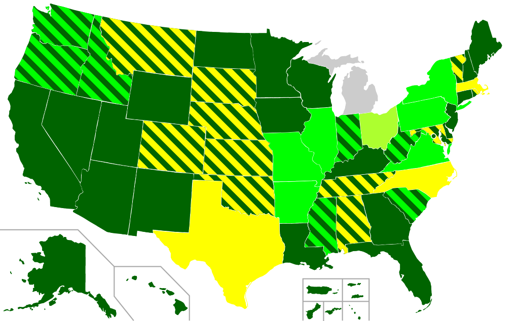
English: A map of the United States outlining where nomination forms of properties listed on the National Register of Historic Places can be downloaded.
Most nominations online at NPS Focus
Most nominations online at state-level or other source
Most nominations online, but require payment
Some nominations online at state-level or other source |
| Date | |
| Source | Based on File:Blank USA, w territories.svg by User:Lokal Profil |
| Author | User:Dudemanfellabra |
Licensing[edit]
This file is licensed under the Creative Commons Attribution-Share Alike 3.0 Unported license.
- You are free:
- to share – to copy, distribute and transmit the work
- to remix – to adapt the work
- Under the following conditions:
- attribution – You must give appropriate credit, provide a link to the license, and indicate if changes were made. You may do so in any reasonable manner, but not in any way that suggests the licensor endorses you or your use.
- share alike – If you remix, transform, or build upon the material, you must distribute your contributions under the same or compatible license as the original.
File history
Click on a date/time to view the file as it appeared at that time.
| Date/Time | Thumbnail | Dimensions | User | Comment | |
|---|---|---|---|---|---|
| current | 19:56, 8 March 2015 | | 959 × 593 (109 KB) | Dudemanfellabra (talk | contribs) | Focus was updated with a huge batch back in September/October 2014 |
| 16:44, 17 March 2014 |  | 959 × 593 (116 KB) | Magicpiano (talk | contribs) | Better. | |
| 16:41, 17 March 2014 |  | 959 × 593 (109 KB) | Magicpiano (talk | contribs) | Reverted to version as of 00:48, 30 December 2013; messed something up | |
| 16:39, 17 March 2014 |  | 959 × 593 (119 KB) | Magicpiano (talk | contribs) | Arkansas has nomination forms online. | |
| 00:48, 30 December 2013 |  | 959 × 593 (109 KB) | Dudemanfellabra (talk | contribs) | Idaho has all/most online at state source | |
| 18:21, 14 December 2013 |  | 959 × 593 (109 KB) | Dudemanfellabra (talk | contribs) | Oregon now has most nominations at state-level source | |
| 06:14, 8 October 2013 |  | 959 × 593 (109 KB) | Dudemanfellabra (talk | contribs) | Fix for stray stripes | |
| 07:07, 2 October 2013 |  | 959 × 593 (109 KB) | Dudemanfellabra (talk | contribs) | Fix for AL, DC, possibly for stray stripes | |
| 05:29, 2 October 2013 |  | 959 × 593 (112 KB) | Dudemanfellabra (talk | contribs) | update to use stripes for states with documents in focus and at state-level sources | |
| 18:25, 25 March 2013 |  | 959 × 593 (97 KB) | Dudemanfellabra (talk | contribs) | IN -> State with all |
You cannot overwrite this file.
File usage on Commons
There are no pages that use this file.
File usage on other wikis
The following other wikis use this file:
- Usage on en.wikipedia.org
- Wikipedia:WikiProject National Register of Historic Places/Resources
- Wikipedia talk:WikiProject National Register of Historic Places/Archive 52
- Wikipedia:Graphics Lab/Map workshop/Archive/Mar 2013
- Wikipedia talk:WikiProject National Register of Historic Places/Archive 55
- Wikipedia talk:WikiProject National Register of Historic Places/Archive 57