File:NPS new-river-gorge-lansing-fayetteville-trail-map.jpg
Jump to navigation
Jump to search

Size of this preview: 287 × 600 pixels. Other resolutions: 115 × 240 pixels | 229 × 480 pixels | 367 × 768 pixels | 490 × 1,024 pixels | 2,002 × 4,184 pixels.
Original file (2,002 × 4,184 pixels, file size: 1.52 MB, MIME type: image/jpeg)
Captions
Captions
Add a one-line explanation of what this file represents
Summary[edit]
| Description |
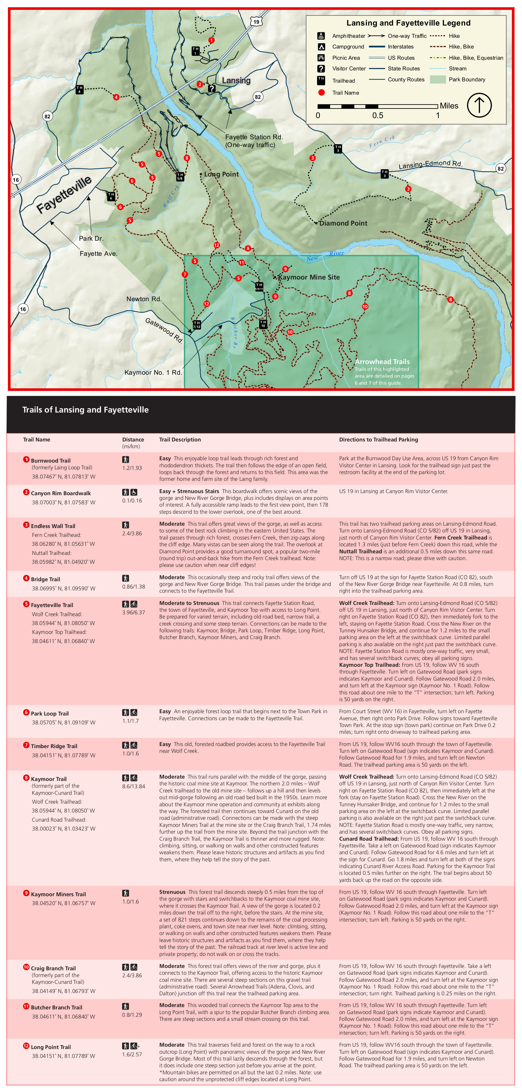
English: The Lansing and Fayetteville trail map shows the very popular area of the New River Gorge and labels a number of trail options. Here’s where you can see the New River Gorge Bridge – don’t miss it! |
| Date | |
| Source | U.S. National Park Service (http://npmaps.com/wp-content/uploads/new-river-gorge-lansing-fayetteville-trail-map.jpg) |
| Author | U.S. National Park Service, restoration/cleanup by Matt Holly |
Licensing[edit]
| This image or media file contains material based on a work of a National Park Service employee, created as part of that person's official duties. As a work of the U.S. federal government, such work is in the public domain in the United States. See the NPS website and NPS copyright policy for more information. |
File history
Click on a date/time to view the file as it appeared at that time.
| Date/Time | Thumbnail | Dimensions | User | Comment | |
|---|---|---|---|---|---|
| current | 01:32, 17 May 2017 | | 2,002 × 4,184 (1.52 MB) | RKBot (talk | contribs) | =={{int:filedesc}}== {{Information |description= {{en|1=The Lansing and Fayetteville trail map shows the very popular area of the New River Gorge and labels a number of trail options. Here’s where you can see the New River Gorge Bridge – don’t mi... |
You cannot overwrite this file.
File usage on Commons
The following page uses this file: